Brunei
 |
|
Contact person for provided information:
Dk Siti Saihalina Pg Hj Ibrahim
Survey Department
B.S.B. BB3510, Brunei Darussalam
info@survey.gov.bn
Pg Norhashimi Pg Hj Bungsu
Survey Department
B.S.B. BB3510, Brunei Darussalam
info@survey.gov.bn
Part 1: Country Report
A. Country Context
A.1 Geographical Context
Brunei Darussalam – in Borneo Island with Malaysia and Indonesia (states).
Brunei Darussalam is situated on the north-west of the island of Borneo, between east longitudes 114 degrees 04' and 114 degrees 23' and north latitudes of 4 degrees 00' and 5 degrees 05'. It has a total area of 5,765 sq.km. with a coastline of about 161 km along the South China Sea. It is bounded on the North by the South China Sea and on all the other sides by Malaysian State of Sarawak.
Mid-year population estimates of Brunei Darussalam for 2017 was 421,300 persons compared to 417,256 persons in the Population and Housing Census Update 2016. This represented an average annual growth rate of 1.0 per cent during the period. Of the said total, 216, 400 (51.36%) are males and 204,900 (48.64%) are females. (http://www.depd.gov.bn/SitePages/Population.aspx, accessed on 8th September 2018).
The land surface is developed on bedrock of tertiary age comprising of sandstone, shale and clays. The terrain in the western part of Brunei Darussalam is predominantly hilly lowland below 91 metres, but rising in the hinterland to about 300 metres. The eastern part of the state consists predominantly of rugged mountain terrain, rising 1,850 metres above sea level at Bukit Pagon. The coast has a wide, tidal and swampy plain.
A.2 Historical Context
The 1959 Constitution provides for The Sultan as the Head of State with full executive authority. The Sultan is assisted and advised by five councils - the Religious Council, the Privy Council, the Council of Ministers (the Cabinet), the Legislative Council and the Council of Succession
The 1959 Constitution established the Chief Minister as the highest official, with the British High Commissioner as adviser to the Government on all matters except those relating to the Muslim religion and Malay customs. Effectively, however, in all internal and financial matters, the country has been self-governing.
Land administration was first handled by the British Resident which has the power to issue the letter of ownership to land applicants until the "Declaration of Constitution" in 1959 where this power was given to His Majesty Duli Yang Maha Mulia Paduka Seri Baginda Sultan and Yang Di-Pertuan Negara Brunei Darussalam through Sultan in Council.
A.3 Current Political and Administrative Structures
Brunei is an independent sovereign Sultanate which is governed on the basis of a written Constitution.
His Majesty The Sultan and Yang Di-Pertuan is the supreme executive authority in Brunei Darussalam. His Majesty has occupied the position of Prime Minister since resumption of independence in 1984.
Brunei's administrative system is centred on the Prime Minister's Office which has provided the thrust behind His Majesty's aim to introduce greater efficiency in the Government. In his National Day speech in 1987, His Majesty pointed out that it was essential to keep the country's administrative machinery up-to-date in line with the development of Brunei as an independent nation. His Majesty has followed a combination of traditional and reforming policies, moving away from a structure of a Chief Minister and State Secretary to a full ministerial system with specified portfolios.
Since independence in 1984, there are only twelve ministries. In 2010, the Energy Department under Prime Minister's Office was established, and on 18 April 2018 it was separated from the Ministry and upgraded to a cabinet-level ministry with the name Ministry of Energy and Industry. It then changed to Ministry of Energy (Energy and Manpower) and Industry on 30 July 2018. The list of ministries under Brunei Government as listed below:
- Prime Minister's Office
- Ministry of Finance
- Ministry of Defence
- Ministry of Foreign Affairs and Trade
- Ministry of Home Affairs
- Ministry of Education
- Ministry of Primary Resources and Tourism
- Ministry of Development
- Ministry of Culture, Youth and Sports
- Ministry of Health
- Ministry of Religious Affairs
- Ministry of Communications
- Ministry of Energy (Energy and Manpower) and Industry
A.4 Historical Outline of Cadastral System
B. Institutional Framework
B.1 Government Organizations
The current Government Adminitration are as follow:
- Prime Minister's Office
- Ministry of Finance
- Ministry of Defence
- Ministry of Foreign Affairs and Trade
- Ministry of Home Affairs
- Ministry of Education
- Ministry of Primary Resourses and Tourism
- Ministry of Development
- Ministry of Culture, Youth and Sports
- Ministry of Health
- Ministry of Relgious Affairs
- Ministry of Communications
- Ministry of Energy (Energy and Manpower) and Industry
Survey Department is the authority to produced Land Titles (but not registration), plans, maps and other matters regarding cadastral surveys, demarcation etc. Other government that are involved in Land Administration include Land Departments (registration, transfers), Town and Country Planning (planning, master plans etc). All the three Departments are under the Ministry of Development.
B.2 Private Sector Involvement
Most cadastral surveys are undertaken by the government but Licence Land Surveyors (LLS) involvement in cadastral surveys are subdivision, revision surveys and TOL surveys.
Qualification of a Licence Land Surveyors is required to pass an exam on cadastral surveys, planning issues and land administration set by Brunei Surveyors Board. Renewal of licence will be done annually and LLS need to ensure no pending payment to the Survey Department.
By August 2018, 12 license land surveyors are registered in Brunei Darussalam.
B.3 Professional Organization or Association
BIG (Brunei Institution of Geomatics) was established in 2003 and currently inviting Geomatics practitioners in Brunei to join. BIG membership compromised of Surveyors, Valuers and Planners.
B.4 Licensing
Brunei Licence Land Surveyors act is being used for licencing and registration of Cadastral surveyors.
B.5 Education
Surveying programs up to technician level is currently provided in Institute Brunei Technical Education. Whereas higher level mainly available overseas such as Universities in U.K., Canada, Australia and Malaysia.
C. Cadastral System
C.1 Purpose of Cadastral System
Brunei Cadastral system was designed for the purpose of registration, transfer of ownership, any land development, sub division and consolidation and others.
C.2 Types of Cadastral System
Cadastral systems for the whole of Brunei is based on torren systems and use lot number as the identifier. Two departments are involved in cadastral i.e. Survey Departments providing the technical aspects, surveys, mapping etc and Lands Department providing the Registration, transfers etc.
Survey Department provides cadastral mapping e.g. Land Titles, Plans, actual surveys e.g. fixing lots, subdivisions where all lot boundaries are fixed with cadastral surveys (demarcations).
Since 1999 Strata Title Act was implemented and Brunei Survey Department is the Authority to carry out survey, to produce plans and Titles. The act was meant to monitor and control Strata Title Survey and to safeguard everyone involved.
C.3 Cadastral Concept
---
C.4 Content of Cadastral System
Total number of Cadastral lots in Brunei by August 2018 is just over 108, 232, these are mostly privately owned lots, Temporary Owner of Land and a number of lots occupied by government departments. The plots have been completely digital and supported by field notes and Survey Plans.
Cadastral database was updated for every 3 hour on the Survey Geoportal through Fusion Manipulation Engine (FME) software.
Most of the survey works done by the government are using 'Field To Finish System' and this includes the production of land title, Certified Plan, the digital survey sheet and updated the cadastral database.
D. Cadastral Mapping
D.1 Cadastral Map
Survey Department is mainly using Oracle database and ArcSDE to store cadastral information. GIS software such as ArcGIS and ERDAS is used as a tools in map production and also to overlay the cadastral information on top of satellite imageries.
Survey Department is currently preparing Cadastral Lots in a form of Sheets at 2,500 scale with information such as lot number (as the identifier) with other information such as district, village boundaries, locations etc. cadastral maps are also available at different scales when requested.
Currently cadastral lots can be viewed freely in the Survey Geoportal.
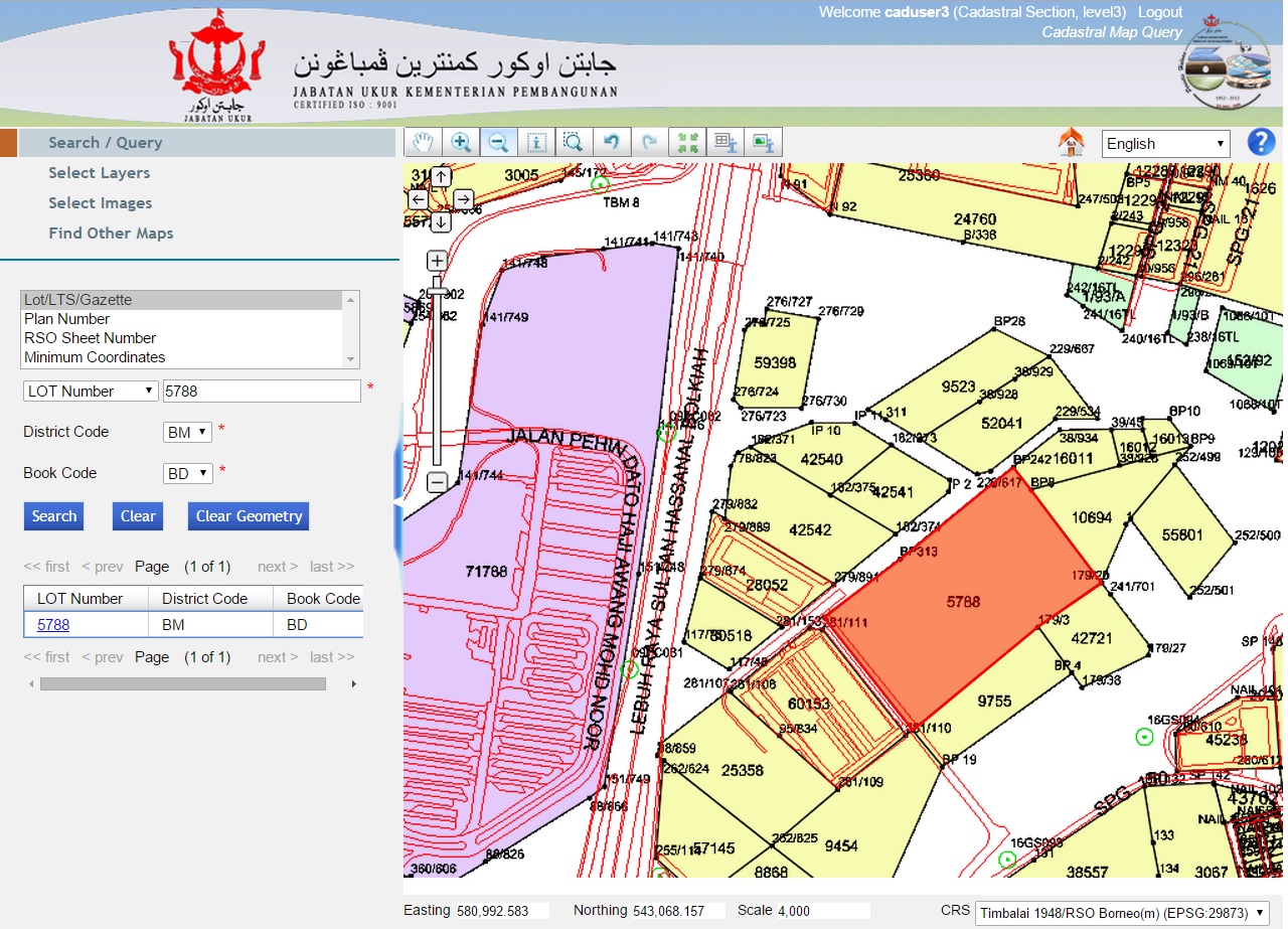
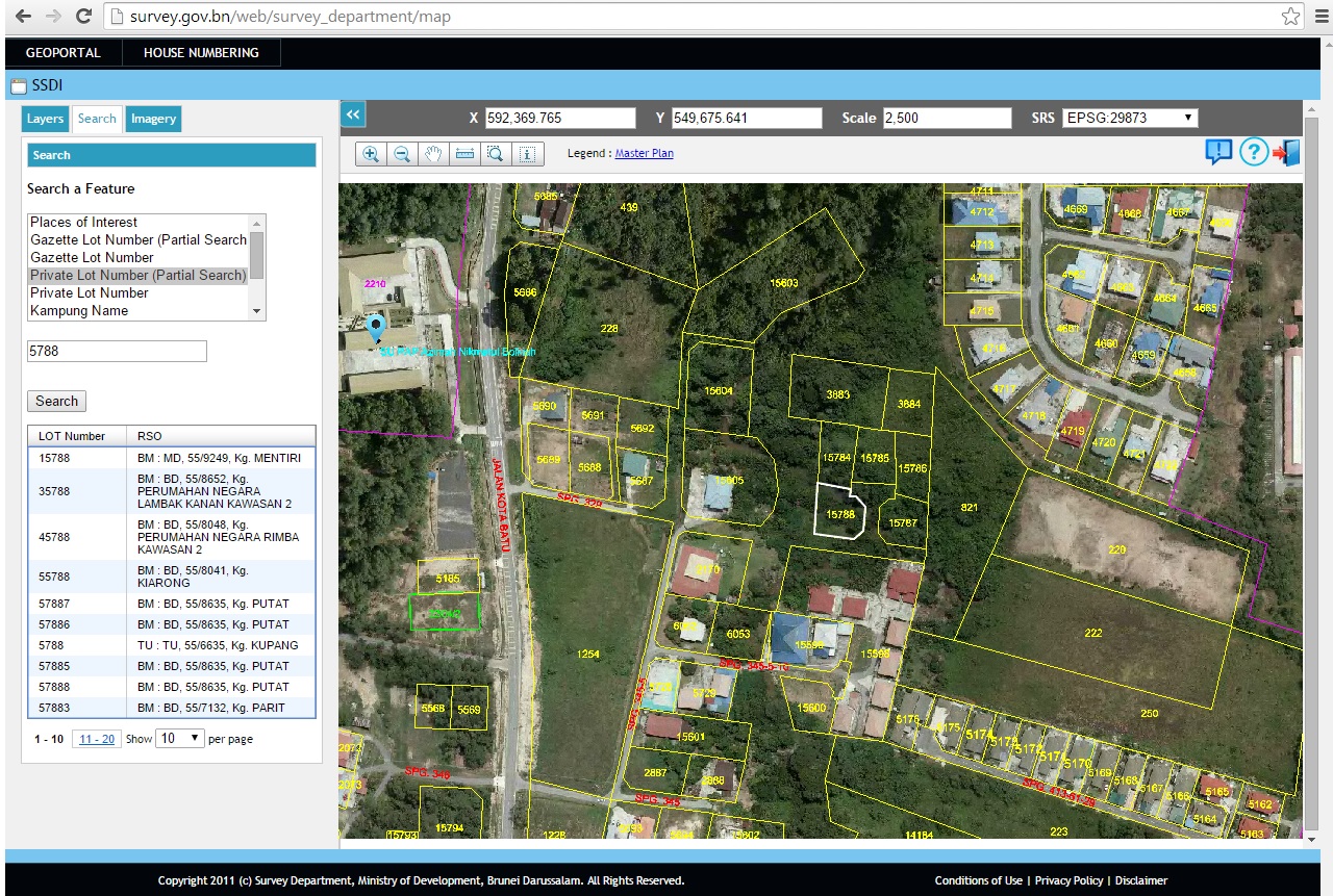
D.2 Example of a Cadastral Map
Below is an example of viewing cadastral lots using Survey Geoportal
D.3 Role of Cadastral Layer in SDI
The Survey Geoportal is one of the government initiatives for survey spatial data infrastructure (SSDI) and as a platform to share data among government agencies, public sectors and private sectors. The basis of teh geoportal are the cadastral lots overlay with the satellite imagery.
Currently Survey Department is on Geoportal of Survey Spatial Data Infrastructure (SSDI) whereby all the cadastral digital maps are available for viewing overlay with the images to departments and public.
Sharing data for Goventment Agency, Public Sector & Private Sectors.
E. Reform Issues
E.1 Cadastral Issues
E.2 Current Initiatives
Digital maps are available within the departments network although initiatives are being made so that this cadastral information is available in the net.
Any application of digital data can be browsed through Geoportal for any development and planning purposes.
F. References
- www.survey.gov.bn
- http://www.mod.gov.bn/survey/Theme/Home.aspx
Part 2: Cadastral Principles and Statistics
1. Cadastral Principles
1.1 Type of registration system |
|
title registration
deeds registration |
1.2 Legal requirement for registration of land ownership |
|
compulsory
optional |
1.4 Approach for establishment of cadastral records |
|
systematic
sporadic both, systematic and sporadic all properties already registered |
2. Cadastral Statistics
2.1 Population |
421,300 |
2.2a Population distribution: percentage of population living in urban areas |
90 |
2.2b Population distribution: percentage of population living in rural areas |
10 |
2.3 Number of land parcels |
108,232 |
--- Number of land parcels per 1 million population |
256,900 |
2.4 Number of registered strata titles/condominium units |
0 |
--- Number of strata titles/condominium units per 1 million population |
0 |
2.5 Legal status of land parcels in URBAN areas: |
|
percentage of parcels that are properly registered and surveyed |
100 |
percentage of parcels that are legally occupied, but not registered or surveyed |
0 |
percentage of parcels that are informally occupied without legal title |
0 |
2.6 Legal status of land parcels in RURAL areas: |
|
percentage of parcels that are properly registered and surveyed |
97 |
percentage of parcels that are legally occupied, but not registered or surveyed |
2 |
percentage of parcels that are informally occupied without legal title |
1 |
2.7 Number of active professional land surveyors |
20 |
2.8 Proportion of time that active professional land surveyors commit for cadastral matters (%) |
100 |
--- Approx. full-time equivalent of land surveyors committed to cadastral matters |
20 |
2.9 Number of active lawyers/solicitors |
0 |
2.10 Proportion of time that active lawyers/solicitors commit for cadastral matters (%) |
0 |
--- Approx. full-time equivalent of active lawyers/solicitors committed to cadastral matters |
0 |