Cambodia
 |
|
Contact person for provided information:
Mr. Suon Sopha
General Department of Cadastre & Geography, Ministry of Land Management, Urban
Planning and Construction
Deputy Director General of General Department of Cadastre and Geography
Building 771-773, Monivong Blvd.Khan Chamcarmon, Phnom Penh.
Sophasuon-at-gmail.com
Part 1: Country Report
A. Country Context
A.1 Geographical Context
Cambodia is located in South-East Asia, with a total area of 181,035 sq km lying north of the equator and next to Vietnam, Thailand, Laos and Gulf of Siam. The population is approximately 15 million, with an annual population growth rate of about 1.6%.
A.2 Historical Context
Cambodia was colonized by the French from 1863 to 1954. After independence, the country had peace until 1970 when Cambodia entered many years of war. Between1970-75, the country suffered civil war and international invasion, and the Khmer Rouge came to power. The Khmer Rouge regime, in addition to killing an estimated two million people, brought about one of the major population displacements of human history, forcing hundreds of thousands to move from cities and towns to the countryside and from one part of the country to the other. In 1978 Cambodians who opposed the Khmer Rouge regime, supported by the Vietnamese army, attacked the Khmer Rouge, liberating Phnom Penh on 7 January 1979. It was not until 1998 that all Khmer Rouge forces stopped fighting in all parts of the country. Beginning in 1979 the country was reconstructed from scratch.
A.3 Current Political and Administrative Structures
The Kingdom of Cambodia consists of three independent power centers. The legislative power is in the National Assembly, the executive power is in the Royal Government, and the judicial power is in the courts. National Assembly members are chosen every 5 years through national elections. The National Assembly creates the Royal Government, which is headed by the Prime Minister. (Starting in 2002 commune councils has also been popularly elected.)
The whole territory of Cambodia contains 25 provinces/municipalities with a total of 197 districts, 1633 communes and 14,138 villages.
A.4 Historical Outline of Cadastral System
The history of modern land management and administration in Cambodia begins with French initiatives in the late 19th century. The first Civil Code was adopted in 1920 and it established a system of French land law that recognized private property rights. Some traditional Cambodian rights, in particular that of creating a land right simply by occupation and possession, were included in the Civil Code. During the 1960s there was an adequate system of land management, including confirmation of private property rights with land records including cadastral maps and land titles. The land management system started deteriorating during the war period 1970-1975. Thereafter under the Pol Pot regime (1975-1979), not only were private property rights completely destroyed but all cadastral records, including cadastral maps and titles, were destroyed. The professionals in land law, land management, registration and surveying were either re-deployed to the countryside, left the country or were executed. Starting in 1979 the State of Cambodia organized collectives as a basis of claiming user rights to agricultural land: residential use rights were allocated on the basis of occupation while ownership of all land remained in the hands of the state. In 1989 the government re-introduced private property rights, with ownership rights granted for residential land of a size up to 2000 sq. meters, possession rights for cultivated lands less than 5 ha, and concession rights for plantation land greater than 5 ha. According to a new land law adopted in 2001, ownership titles can be issued for many types of private uses in addition to residential. In 2011 Cambodia enacted a new Civil Code, which cancelled or modified some provisions of the 2001 land law, but left intact the basic legal regime described above.
B. Institutional Framework
B.1 Government Organizations
Many land issues in Cambodia are the competence of the Ministry of Land Management, Urban Planning and Construction (MLMUPC), which has a wide mandate through five General Departments: General Department of Land Management and Urban Planning, General Department of Construction, General Department of Cadastre and Geography (GDCG), General Department of Administration, and General Department of Housing. The GDCG is responsible for land registration and land administration, geodetic and cadastral surveying, mapping and property valuation. The 197 District and 25 Provincial/Municipal offices of the MLMUPC carry out actual implementation of land registration, administration of land transactions, and land use planning.
B.2 Private Sector Involvement
Up to now there is no private sector in land registration and cadastral surveying. The Government is still discussing specific requirements to introduce a qualification system for surveyors through a draft law on Surveying and Mapping.
B.3 Professional Organization or Association
There is no professional association for cadastral surveyors yet, but at the moment there is the Board of Engineers Cambodia (BEC), derived from The Engineering Institution of Cambodia (EIC) has a committee on Topographical Survey and Cadastre, which has about 20 members. In the draft sub-decree on the Management of Surveying, Mapping activities and Service, Surveyors and surveying firms registered by the MLMUPC may form a surveyor’s association. The MLMUPC shall provide assistance in the organization and establishment of such association. The Ministry of Land Management, Urban Planning and Construction is affiliate member of FIG since 2002.
B.4 Licensing
Currently, there is no licensing system in place for cadastral surveying professionals working in the cadastral system. The Ministry of Land Management, Urban Planning and Construction has drafted a sub-decree on the Management of Surveying, Mapping activities and Service to provide the legal basis for the private sector profession with the goal that most or all land surveys will be done by private sector.
B.5 Education
Between1992-1997 the Land Titles Department (LTD) (later absorbed into the MLMUPC) oversaw a diploma degree on cadastre at the Prek Leap Agricultural College. In those years, systematic in-house training in the LTD took place continuously.
In 2002, the Land Management and Administration Faculty was established in the Royal Agriculture University in Phnom Penh, with the support of the Land Management and Administration Project (LMAP), which was based in MLMUPC. The support covered curriculum development, a professor exchange program, constructing a building, providing furniture and office equipment and equipment to use to train students in surveying and land management. The Faculty established two degrees: a bachelor degree of four years and a diploma degree of two years. LMAP was later discontinued but MLMUPC support to the faculty continues.
C. Cadastral System
C.1 Purpose of Cadastral System
The cadastral system in Cambodia is designed to provide legal ownership of land. The cadastral system also supports the transfer of land ownership in a formal land market and supports land administration activities as well.
C.2 Types of Cadastral System
In Cambodia, there is only one cadastral system—a title registration system—for the whole country. The Cambodian cadastral system supports legal land parcel identification of public and private lands. There are problems with illegal settlements on state land such as on road corridors, waterways, national parks, forests etc.
C.3 Cadastral Concept
The cadastral system in Cambodia is operated by the district offices of the Ministry of Land Management, Urban Planning and Construction and operated in such a way that land parcels are surveyed and adjudicated (investigated) in the field and then corresponding land ownership titles are recorded in the land registry. The land registry is kept and maintained at three levels: national (General Department of Cadastre and Geography), provincial and district. The smallest unit in the land registry is the land parcel. A land parcel or cadastral unit is a specified land area that is situated within a single commune or sangkat ,that is not divided by a joint, indivisible boundary, that belongs to one person or several persons having an undivided ownership, and that is used in a single manner.
There are numerous legal texts that have been adopted to support the cadastral system such as sub-decrees on systematic land registration, sporadic land registration, the Cadastral Commissions and so on.
C.4 Content of Cadastral System
The Cambodia cadastral system comprises the following components:
- Textual Component – The land register shows, according to each parcel number of ownership, the names of owners and the means of identification of such land parcels, the description of the ownership, the size of the land parcel, the easements and other charges that encumber it and the history of the parcel.
- Spatial Component – Cadastral index maps show all land parcels graphically corresponding to the registered parcels with unique identifiers. The cadastral index maps exist only for the areas where systematic land registration has been implemented.
Out of the estimated 7 million parcels in Cambodia, the cadastre covers approximately 4 million (both sporadically and systematically registered land) including privately owned land, Indigenous communal land and state land. 620,000 parcels have been registered since 1990 through sporadic registration and 3.4M have been registered since 2000 through systematic registration.
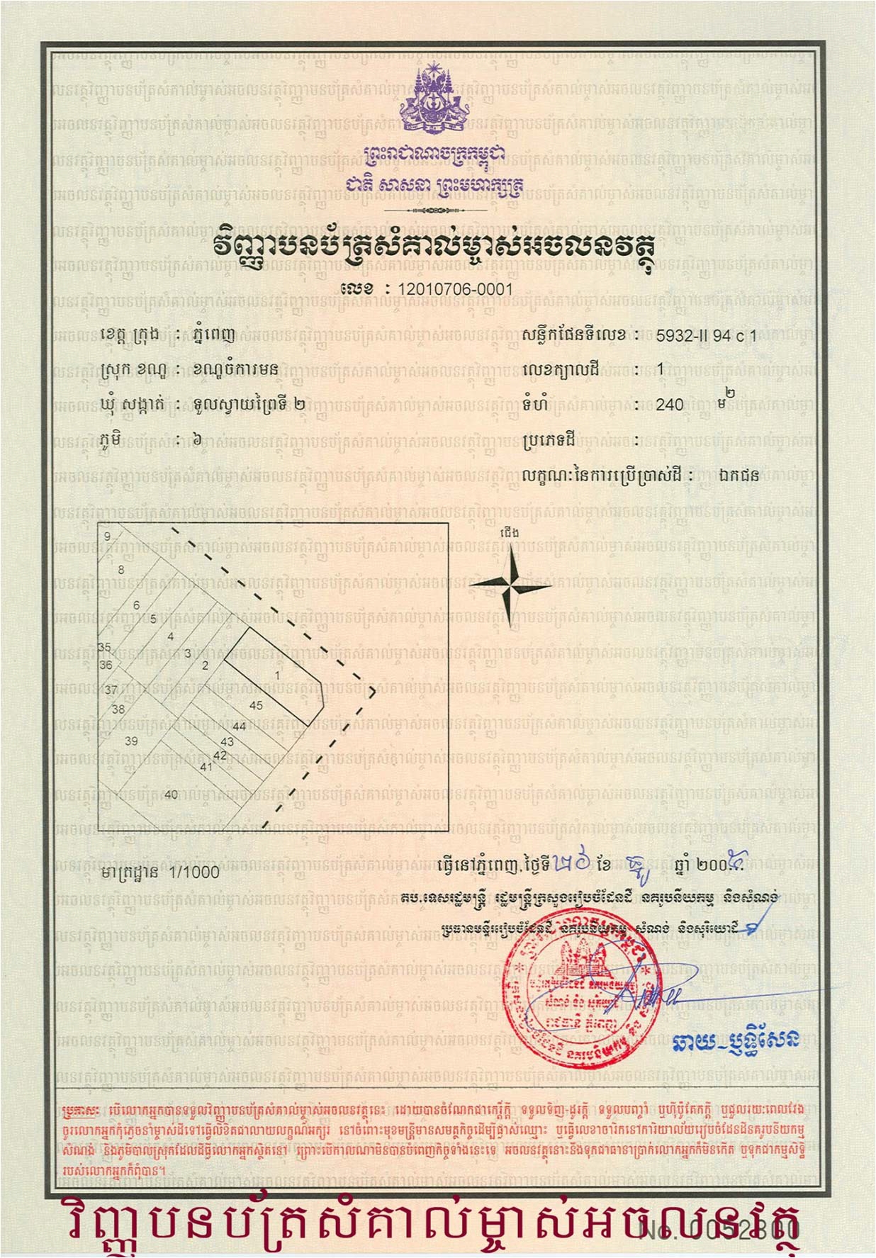
Figure 1
D. Cadastral Mapping
D.1 Cadastral Map
At present day the cadastral index map covers only the systematic land registration areas. Digital orthophoto mapping is facilitating the elaboration of cadastral index map.
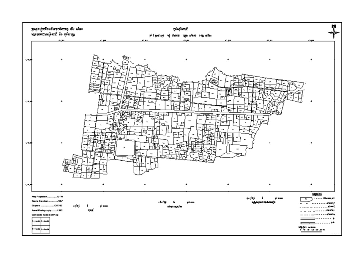
Figure 2: Example of a cadastral index map (overview).
D.2 Example of a Cadastral Map
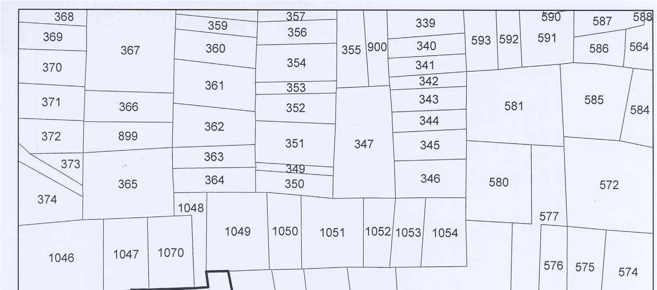
Figure 3: Example of a cadastral index map (detail).
D.3 Role of Cadastral Layer in SDI
Spatial Data Infrastructure (SDI) still has to be developed for Cambodia by the MLMUPC.
E. Reform Issues
E.1 Cadastral Issues
There are two main reform issues, concerning de-concentration and land dispute resolution. Starting in 2002 the MLMUPC has delegated the power to all 25 provincial/municipal offices to issue land titles. There is also a mechanism for out-of-court land dispute resolution through the Cadastral Commissions.
E.2 Current Initiatives
- Draft Law on Surveying and Mapping
- Law on amendment Land Law 2001
- The Land Administration Sub Sector Program to register 400,000 land parcels/year.
F. References
---
Part 2: Cadastral Principles and Statistics
1. Cadastral Principles
1.1 Type of registration system |
|
title registration
deeds registration |
1.2 Legal requirement for registration of land ownership |
|
compulsory
optional |
1.4 Approach for establishment of cadastral records |
|
systematic
sporadic both, systematic and sporadic all properties already registered |
2. Cadastral Statistics
2.1 Population |
15,000,000 |
2.2a Population distribution: percentage of population living in urban areas |
19 |
2.2b Population distribution: percentage of population living in rural areas |
81 |
2.3 Number of land parcels |
7,000,000 |
--- Number of land parcels per 1 million population |
466,600 |
2.4 Number of registered strata titles/condominium units |
0 |
--- Number of strata titles/condominium units per 1 million population |
0 |
2.5 Legal status of land parcels in URBAN areas: |
|
percentage of parcels that are properly registered and surveyed |
59 |
percentage of parcels that are legally occupied, but not registered or surveyed |
34 |
percentage of parcels that are informally occupied without legal title |
7 |
2.6 Legal status of land parcels in RURAL areas: |
|
percentage of parcels that are properly registered and surveyed |
60 |
percentage of parcels that are legally occupied, but not registered or surveyed |
35 |
percentage of parcels that are informally occupied without legal title |
5 |
2.7 Number of active professional land surveyors |
745 |
2.8 Proportion of time that active professional land surveyors commit for cadastral matters (%) |
100 |
--- Approx. full-time equivalent of land surveyors committed to cadastral matters |
745 |
2.9 Number of active lawyers/solicitors |
0 |
2.10 Proportion of time that active lawyers/solicitors commit for cadastral matters (%) |
0 |
--- Approx. full-time equivalent of active lawyers/solicitors committed to cadastral matters |
0 |