Colombia
 |
|
Contact person for provided information:
Daniel Páez Barajas, PhD
Universidad de los Andes
Urban Sustainability and Regional Group Director
Cra1 N° 18A -12 Bogotá, Colombia
sur.uniandes.edu.co
Part 1: Country Report
A. Country Context
A.1 Geographical Context
Colombia is a country of 2’129.748 Km2 where 1’141.748 Km2 of them is continental territory divided in 5 regions and the other 988.000 Km2, its maritime extension. The country limits to the east with Venezuela and Brazil, to the south with Peru and Ecuador and to the north-west with Panama. Colombia in inhabited by more than 48 million people distributed in urban and rural centers, the majority of which is concentrated in urban territory according to DANE’s projections and statistics (DANE, 2010). Topographically speaking the country is characterized for containing the division of the Andes mount range; as a result of this mount range and its latitude, Colombia has all the thermic floors and abundance of biodiversity. In the north of the country is located the highest point of Colombia corresponding to the mountain called Sierra Nevada de Santa Marta, with an altitude close to 5800 m.a.m,s.l. The most important river of the country is the Magdalena River, which crosses through almost all the country, and together with the Cauca River, are the most important channels of fluvial communication that lead to the Caribbean coast. Colombia also is part of the reduced list of countries that have shores in two different oceans. (Colombia.com) According to the sustainable development network of Colombia, the country is the second most biodiverse in the world. “On average, one out of ten species of Fauna and Flora of the world, are founded in Colombia” (RDS)
A.2 Historical Context
Beginning with the precolombian era, where the territory was inhabited by “golden cultures”, as the Taironas, who excel in their skills with ceramics among other cultural aspects, it is also known for its improvements in stone craftsmanship and construction. In 1948, Cristobal Colón arrived to the region of Paria, located in what today is known as Venezuela, opening the path to the process of conquest and colonization of the territory. Rodrigo Bastidas made the first exploration of the Colombian coast in 1500 and different explorers and conquerors, in the search of the coveted treasure of El Dorado, traveled the territory
Later on, the Colombian history takes a determinant turn with the independence period, hand with the abdication of Carlos IV by Napoleon Bonaparte. The crown started to lose control over the conquered territories and the Creoles saw the opportunity to create independence movements in Colombia. By July, 1810, occurred in Santa Fe a turmoil detonated by the well-known incident of the Casa del Florero, that led to the declaration of an open cabildo and to subscribe the independence act, which was followed by several civil wars and the period called “Patria Boba”, called after the political instability that caused the reconquer, when the Spanish crown defeats the French. However, Santander builds an army in the flatlands of Casanare and with English support in arms and local troops, defeats the landowner of the conqueror Murillo, finally gaining independence in August, 1819. The history of Colombia pauses in the deepest trauma that has had so far the separation of Panama (1903), instigated by the interests of the United States on the Canal. Years later in 1932, Colombia enters war with Peru to recover the Amazon´s invaded Gaza; the Liberals come to power and introduce new schemes of land ownership and other aspects. In 1948 the Liberal leader Jorge Eliecer Gaitan was assassinated unleashing a period of violence between the Liberal and Conservative political parties which then led to the creation of guerrilla groups, including the FARC. The pressure and growing power of the guerrilla groups led both political parties to unite in an agreement called "Frente Nacional" that consisted in switching the presidency between them since 1958. However, this strategy failed to eradicate the guerrillas, causing the people to react by creating paramilitary groups, creating once again a terrorist war in the country. The ELN (National Liberation Army) emerges in 1965, the EPL (People's Liberation Army) in 1967 and finally in 1973 appears the M-19. Years later in 1990, a group of university students held a plebiscite resulting in the democratic formation of the Constituent Assembly, which conducted the Constitution of Colombia of 1991. Finally, the illegal drug trade reaches the country through the Cali and Medellin cartels, who shocked the country with terrorist acts, which only weakened with the death of Pablo Escobar; However, the country still has high rates of drug trafficking and is currently in peace negotiations to end the conflict with the still existing guerrilla FARC. (histopolitica)(Colombia)
A.3 Current Political and Administrative Structures
Colombia is a social state of law and its government is divided in 3 branches of government, the legislative, executive and judicial branches. The country has 1123 municipalities, 32 departments and five districts; each city or municipality is run by a mayor and its city council, at the same time each department has a governor who serves as the coordinating link between the nation and municipalities. Everyone in charged, including the President of the Republic and other government representatives are elected in popular elections (Colombia, 2016).
A.4 Historical Outline of Cadastral System
“With the law 14 of 1983, the Colombian congress defined cadastre as a multipurpose inventory, with which it was pretended to give local authorities the right instruments for municipal planning. In the law decree 14, it was established that the cadastre is the inventory or survey, properly updated and classified, of the real state goods belonging to the government and particulars, with the objective of achieving a proper physical, legal and economic identification” (Bermúdez & Fonti Garolera, 2007)
The cadastre in Colombia started with the General Francisco de Paula Santander, who established it in 1825, with the purpose of sustaining the independence war, then in 1908 with the issuance of the decree 1227, the cadastre is formed in all the country. Later, with law 4 of 1913, the assemblies had the possibility to create their own cadastral regulation, as they were given the faculty to regulate and establish the tax on the real state property. However, the entities in charge of the appraisals were slow and produced a fractionated and outdated cadastre. In 1930, Public Finances entrusted the Swiss mission Kemmerer to modernize and rationalize taxation. They created an appraisal entity and began the creation of land footprints and maps to specify the topographical details of the land estates; moreover, landowners’ direct declaration was also recognized as a method to form the cadastre and the 5-year appraisal review principle. In 1935, the Cadastral Military Geographic Institute was founded with the purpose of developing the country’s military inventory, which was then replaced by the Agustin Codazzi Geographic Institute.
With the issuance of Law 14 of 1983 and Decree 3496, a new and more efficient system of appraisals and an update of the cadastre was implemented. More recently, in the early 90s, the implementation of technological tools was started by a technological modernization project carried out by the IGAC and the financial support between the Swiss and Colombian governments. This resulted in the construction of the Colombian Spatial Data Infrastructure. In 1997, the Republic of Colombia and the IDB signed the loan agreement BID1027 / OC-CO in order to consolidate the land market and ensure the legal security of property, by modernizing and the interrelation of wastelands, program that was assigned to the IGAC as executing agency in 2001. With the intervention of the Superintendence of Notaries and Registration and the Colombian Institute of Agrarian Reform, it was established a system of land information by 2005. Today Cadastre in Colombia is handled by the IGAC and other decentralized entities in Antioquia, Bogotá, Cali and Medellin. (Rodríguez Ramos)
B. Institutional Framework
B.1 Government Organizations
-Ministries involved in Colombia with Cadaster and land administration:
-Ministry of Treasury and Public Credit -Ministry of Housing, City and Territory –Ministry of Environment and Sustainable Development
IGAC-Geographic Institute Agustín Codazzi – National Entity
-Territorial Sub-Division, Territorial Management Guajira, Territorial Management Magdalena, Territorial Management Cesar, Territorial Management Atlántico, Territorial Management Norte de Santander, Territorial Management Bolívar, Territorial Management Sucre, Territorial Management Córdoba, Territorial Management Antioquia, Territorial Management Risaralda, Territorial Management Santander, Territorial Management Meta, Territorial Management Boyacá, Territorial Management Caldas, Territorial Management Caquetá, Territorial Management Cauca, Territorial Management Valle, Territorial Management Quindío, Territorial Management Huila, Territorial Management Tolima, Territorial Management Nariño, Territorial Management Cundinamarca
Local/regional Subdivision (UOC)
-Cadastral Operational Unit of San Juan del Cesar- Cadastral Operational Unit in Aguachica- Cadastral Operational Unit in El Banco- Cadastral Operational Unit in Curumaní- Cadastral Operational Unit in Sabanalarga- Cadastral Operational Unit in San Andrés- Cadastral Operational Unit in Ocaña- Cadastral Operational Unit in Pamplona- Cadastral Operational Unit in Mompox- Cadastral Operational Unit in Quibdó- Cadastral Operational Unit in Barrancabermeja- Cadastral Operational Unit in Málaga- Cadastral Operational Unit in San Gil- Cadastral Operational Unit in Vélez- Cadastral Operational Unit in Arauca- Cadastral Operational Unit in San Martin- Cadastral Operational Unit in Yopal(Casanare)- Cadastral Operational Unit in Chiquinquirá- Cadastral Operational Unit in Duitama- Cadastral Operational Unit in Garagoa- Cadastral Operational Unit in Puerto Boyacá- Cadastral Operational Unit in Soatá- Cadastral Operational Unit in Sogamoso- Cadastral Operational Unit in Quilichao- Cadastral Operational Unit in Buenaventura- Cadastral Operational Unit in Buga- Cadastral Operational Unit in Cartago- Cadastral Operational Unit in Palmira- Cadastral Operational Unit in Tuluá- Cadastral Operational Unit in Chaparral- Cadastral Operational Unit in Honda- Cadastral Operational Unit in Ipiales- Cadastral Operational Unit in Mocoa(Putumayo)- Cadastral Operational Unit in Fusagasugá- Cadastral Operational Unit in Gachetá- Cadastral Operational Unit in Girardot- Cadastral Operational Unit in Guaduas- Cadastral Operational Unit in La Mesa- Cadastral Operational Unit in Leticia- Cadastral Operational Unit in Pacho- Cadastral Operational Unit in Soacha- Cadastral Operational Unit in Ubaté- Cadastral Operational Unit in Zipaquirá
Cadastral Entities different from IGAC in Colombia:
-UAECD- Special Administrative Unit of District Cadaster –Entity of Bogotá
-Management Information Systems and Cadaster- Antioquia Entity
-Under secretariat of Cadaster of Medellín- Medellín Entity
-Sub-Division of Municipal Cadaster of Santiago de Cali- Cali Entity
B.2 Private Sector Involvement
The private sector assumes the costs and develops operational tasks such as land measurements. Furthermore, private sector may proceed to the real state register, and the costs of these processes are paid by the parts that participate in the transactions or registers, so in this way the private sector basically establishes itself as the procurer of the cadastral tasks and the public sector acts as a supervising third party. (Kaufman y Steudler, 2014)
B.3 Professional Organization or Association
National Professional Council of Topography: "it's a government organization created through law 70 of 1979 and the regulatory decree 690 of 1981”. Its mission is “to support and promote the lawful exercise of thee within Colombia's republic.”(CPNT).
The rightful members of this council are: minister of Public Works, minister of Education, a representative of the National Association of Universities, two members chosen by the trade associations of topographers and all remaining members must be topographers.
The Colombian society of Topographers: "it's an advisory body created by the government, for everything related with topography and specially activities related to the development of it within the country.”(SCT)
B.4 Licensing
According the National Professional Council of Topography, there are obligatory requirements for issuing a license to a topographer, those who are shown in the next list:
- Professional Title
- Topographer’s Diploma
- College Diploma
- ID photocopy
- Recent color photography with blue background, 3x4 sized, up front and with formal suit.
- Scanned consignation receipt stamped by the bank (it’s necessary to pay a minimum of 350000 COP and it will be charged with additional fees related to certificate involved processes and mail services, scaling up to approximately 396000 COP.(CPNT)
B.5 Education
At “Guiaacademica.com” it is possible to find 11 institutions that offer the program “technology in topography”, two regarding “professional technics in topography”, one related to “cadastral engineering and geodesy. Likewise, Sena and IGAC have opened program about “Topography technicians” (SENA VIRTUAL, 2011). There are also specialization courses related to the topic of interest that can be accessed by interested civil engineers. For that, is possible to include civil engineering, career offered at 88 institutions throughout the whole country. In conclusion, near 100 institutions in the country offer educational programs related with topography, cadastral engineering and civil engineering.
C. Cadastral System
C.1 Purpose of Cadastral System
The cadastral system is conceived as a tool that is dependent of the State, and which stores cartographic and numerical information of rural and urban real estate. The cadastral system seeks to order the geographical space to encourage urban development and make an inventory of all the properties that the country has through accuracy and the timely definition of real estate and property.
As for the legal role, one of the functions is to update cadastral land records. As the properties are constantly changing, both in their physical form and in their property rights, cadaster must ensure that these changes are notified in their statistics for new appraisals and new information. It is also important that the cadastral system help natural and legal persons when they notify these changes. The cadastre system provides peace and land safety to avoid people becoming victims of frauds.
Another important function of cadaster in its fiscal role is to allocate and manage property tax resources. The appraisal and valorization of property depends on its location and the associated land use.
The cadaster system has areas in charge of providing urban planning and development services in different locations, to meet the demand for public services and to enforce policies and commitments that have been made with the government.
C.2 Types of Cadastral System
In 1958 all the departmental agencies of cadaster where dependent of the IGAC (geographic institute Agustin Codazzi), with the exception of Bogota, Antioquia and Medellin. After 1980, Cali separated from IGAC, creating the sub direction of the municipal cadaster of Cali. Having different cadastral systems has brought delays concerning the actualization of data and therefor delays trying to solve problems such as register and identification of wastelands.
Antioquia Cadastral roles correspond to the management of the systems of cadastral information, attached to the government’s administrative department of planning agency. In Bogota, the cadastral authority is linked to the districts secretary Treasury. In Medellin, the sub secretary of cadaster is annexed to cities secretary of Treasury and finally in Cali, the sub direction of municipal cadaster goes attached to cities secretary of Treasury.
C.3 Cadastral Concept
Main measurements that are registered in the cadastral systems, departments and municipalities are: location, nomenclature or name, bordering, placement, cadastral ID and footing, if exist. It is important to show the definitions for used terms in cadaster:
Land Parcel: partition of land
Ownership units: Delimited space of land
Property: rightful ownership of a good
Legal titles: document which the law grants a forced compliance
C.4 Content of Cadastral System
In the actual processes, updating the cadastral information of the properties is not an easy work and are being transcribed into a document called the property file card, which is being moved to digital format due to the amount of information it contains. Nowadays mobile devices are used to capture data, according to the Cadastral document Management, which looks for order, inventory, scanning and final disposition of the property file cards.
D. Cadastral Mapping
D.1 Cadastral Map
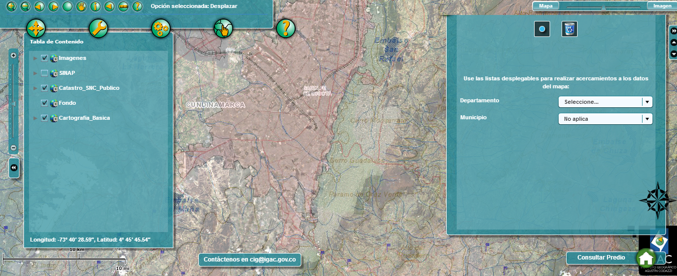
The Agustin Codazzi Geographic Institute has a portal that can be used as a tool to facilitate access to land information in the country. The cadastral map is interactive, it includes surface images of the Colombian territory, and it also includes tools for consulting and geographically identifying properties through cadastral certificates, real estate registration or simply by address, accessing the official website of the Codazzi Institute> > Maps of Colombia >> Map of the National Cadastral System.
In "Maps of Colombia”, there are also several maps with relevant information to the benchmarking of new services and it includes the option of adding maps to interrelate information.
The direct link to the map of Colombia’s cadastral system is:
http://geoportal.igac.gov.co/ssigl2.0/visor/galeria.req?mapaId=23
D.2 Example of a Cadastral Map
D.3 Role of Cadastral Layer in SDI
The Spatial Data Infrastructure for the Capital District - IDECA , is defined as the set of data, standards , policies, technologies and institutional arrangements that integrated and sustained manner , facilitate the production , availability and access to geographic information Capital District in order to support their social , economic and environmental development . IDECA is coordinated by the Special Administrative Unit District Land Registry - UAECD(CatastroBogota)
E. Reform Issues
E.1 Cadastral Issues
Outdated cadaster: "The urban cadaster shows that 6,083,244 properties are updated, corresponding in 660 municipalities, and 3,999,064 are outdated, corresponding to 331 municipalities, while in rural cadaster there are 1,413,975 updated properties in 340 municipalities and 1,972,451 576 outdated properties in 576 municipalities." (Gómez, 2015). According to Juan Antonio Nieto, general manager of IGAC, keeping Colombia’s cadaster updated is a challenge, and by 2014 only 75 municipalities in 19 departments, out of the 995 municipalities that are in charge of IGAC, had been updated (Dinero Magazine, 2014).
Land Restitution in Colombia: "The displaced population has been forced to leave behind 5.5 million hectares of land" (País-Real). The country's peasants have been forced to sell or abandon their land, leaving it in the hands of the third parties that managed to take over it through threats and violence (País-Real). The Colombian government is implementing a victim and land restitution law, to return lands that were stripped through violence to their rightful owners.
Inefficient tax collection: "Colombia has a better level of property tax collection than many countries of the same economic development level, but there is a high inequity in taxation." (Ministry of Agriculture and Rural Development). Tax collection in rural areas is poor compared to tax collection in urban areas; this can be asserted because the tax rates in rural areas are flat, rather than being progressive, regardless of the extent of the territory or its exploitation, causing said inequity in taxation.
E.2 Current Initiatives
This instrument will allow the governance of rural land to arise from the arrangement and real knowledge of the situation of the premises and its occupants, according to the director of IGAC (Agustin Codazzi Geographic Institute). These new provisions will become "the new public land policy." Nieto Escalante highlights the fact that with an outdated cadaster it will not be possible to achieve peace in the country and it would not be possible to "speak of administration and governance of rural land, if you do not have a system of land ownership information that is updated and complete", due to which he proposes the multipurpose cadaster, an administration and land management that departs from the "disposition and real knowledge of the situation of the properties and their holders, occupants, owners and homeowners." With this idea, he also aims to end with legal uncertainty, gaps and fiscal constraint and, more importantly, with the lack of cadastral updating, ensuring an interrelation between the cadaster and registration, supplementing the country’s current needs as a cornerstone for post-conflict. (Torres, 2015)
F. References
Bermúdez, J. A., & Fonti Garolera, J. (2 de 7 de 2007). Una Aproximación al Catastro en Colombia.4. el catastro colombiano. Colombia: Revista UD y La Geomática.
Bogotá, c. (s.f.). Bogotá. Recuperado el 12 de febrero de 2016, de bogota.gov: http://www.catastrobogota.gov.co/index.php?q=es/sections/página-de-inicio
catastral, G. (s.f.). igac. Recuperado el 12 de febrero de 2016, de igac: http://www.igac.gov.co/wps/wcm/connect/3c7947004c993eeca7ffaf64a8e89bec/revista+completa+50.pdf?MOD=AJPERES
catastro. (s.f.). monografías. Recuperado el 12 de febrero de 2016, de monografias.com: http://www.monografias.com/trabajos92/catastro-y-funciones/catastro-y-funciones.shtml
catastro, E. d. (2005). Estadística catastral. Recuperado el 2016, de http://www.igac.gov.co/wps/wcm/connect/3c7947004c993eeca7ffaf64a8e89bec/revista+completa+50.pdf?MOD=AJPERES
Colombia. (s.f.). Recuperado el 09 de 04 de 2016, de http://www.colombia.com/colombia-info/historia-de-colombia/
Colombia, M. (2016). Colombia CO. Recuperado el 14 de 2 de 2016, de http://www.colombia.co/asi-es-colombia/como-es-la-organizacion-politico-administrativa-de-colombia.html
Colombia.com. (s.f.). Recuperado el 09 de 04 de 2016, de http://www.colombia.com/colombia-info/informacion-general/geografia/
CPNT. (s.f.). Recuperado el 05 de 02 de 2016, de http://www.cpnt.org/
CPNT. (s.f.). Recuperado el 5 de 2 de 2016, de http://tramites.cpnt.gov.co/login
DANE. (29 de 10 de 2010). Recuperado el 2016 de 04 de 09, de http://www.dane.gov.co/index.php/poblacion-y-demografia/proyecciones-de-poblacion
Dinero. (2 de 25 de 2014). Dinero. Recuperado el 22 de 02 de 2016, de http://www.dinero.com/pais/articulo/asi-sera-actualizacion-catastral/192553
Gómez, F. (7 de 5 de 2015). CM&. Recuperado el 21 de 2 de 2016, de http://www.cmi.com.co/58-de-los-predios-rurales-en-el-pais-estan-desactualizados
histopolitica. (s.f.). Recuperado el 09 de 04 de 2016, de http://wsp.presidencia.gov.co/asiescolombia/histopolitica.html
igac, p. c. (2015). igac.gov.co. Recuperado el 2016, de igac.gov.co: http://www.igac.gov.co/wps/portal/igac/raiz/iniciohome/Contratacion/ContratosRealizados
Kaufmann, J., & Steudler, D. (2014). FIG. Recuperado el 6 de 2 de 2016, de https://www.fig.net/resources/publications/figpub/cadastre2014/translation/c2014-spanish.pdf
Melo, J.O. (sin fecha) “Historia de la población y ocupación del territorio colombiano” http://www.jorgeorlandomelo.com/histpobla.htm
Ministerio de agricultura y Desarrollo Rural. (s.f.). Recuperado el 21 de 04 de 2016, de http://formalizacion.minagricultura.gov.co/sites/default/files/Nuevo_Catastro_Rural_0.pdf
País-Real. (s.f.). Recuperado el 21 de 2 de 2016, de http://pais-real.blogspot.com.co/2010/09/las-caras-del-despojo-de-tierras-en.html
RDS. (s.f.). Red de desarrollo sostenible de Colombia. Recuperado el 09 de 04 de 2016, de http://www.rds.org.co/biodiversidad2/
Rodríguez Ramos, L. (s.f.). La Modernización Del Catastro Colombiano. Historia del Catastro Colombiano. Colombia: Universidad de los Andes.
SCT. (s.f.). Recuperado el 5 de 2 de 2016, de http://www.sct.org.co/index.php/quienes-somos
SENA VIRTUAL. (6 de 12 de 2011). Obtenido de http://www.sena-virtual.co/convenio-sena-y-agustin-codazzi-abren-inscripciones-para-especializacion/
Torres, G. (8 de 5 de 2015). IGAC. Recuperado el 22 de 02 de 2016, de http://www.igac.gov.co/wps/wcm/connect/7356220047f1a0a6a449a44a5da3094c/Catastro+multiprop%C3%B3sito.pdf?MOD=AJPERES
Part 2: Cadastral Principles and Statistics
1. Cadastral Principles
1.1 Type of registration system |
|
title registration
deeds registration |
1.2 Legal requirement for registration of land ownership |
|
compulsory
optional |
1.4 Approach for establishment of cadastral records |
|
systematic
sporadic both, systematic and sporadic all properties already registered |
2. Cadastral Statistics
2.1 Population |
48,320,000 |
2.2a Population distribution: percentage of population living in urban areas |
72 |
2.2b Population distribution: percentage of population living in rural areas |
28 |
2.3 Number of land parcels |
15,000,000 |
--- Number of land parcels per 1 million population |
310,400 |
2.4 Number of registered strata titles/condominium units |
0 |
--- Number of strata titles/condominium units per 1 million population |
0 |
2.5 Legal status of land parcels in URBAN areas: |
|
percentage of parcels that are properly registered and surveyed |
66 |
percentage of parcels that are legally occupied, but not registered or surveyed |
8 |
percentage of parcels that are informally occupied without legal title |
26 |
2.6 Legal status of land parcels in RURAL areas: |
|
percentage of parcels that are properly registered and surveyed |
16 |
percentage of parcels that are legally occupied, but not registered or surveyed |
10 |
percentage of parcels that are informally occupied without legal title |
74 |
2.7 Number of active professional land surveyors |
0 |
2.8 Proportion of time that active professional land surveyors commit for cadastral matters (%) |
33 |
--- Approx. full-time equivalent of land surveyors committed to cadastral matters |
0 |
2.9 Number of active lawyers/solicitors |
0 |
2.10 Proportion of time that active lawyers/solicitors commit for cadastral matters (%) |
33 |
--- Approx. full-time equivalent of active lawyers/solicitors committed to cadastral matters |
0 |