Iceland
 |
|
Contact person for provided information:
Tryggvi Már Ingvarsson
Manager, Geoinformation department
Registers Iceland
Hafnarstræti 105, 600 Akureyri, Iceland
tmi@skra.is
Inga Elísabet Vésteinsdóttir
Geographer, Geoinformation department
Registers Iceland
Hafnarstræti 105, 600 Akureyri, Iceland
iev@skra.is
Hjörtur Grétarsson
Director of Property Registration
Registers Iceland
Borgartún 21, 105 Reykjavík, Iceland
hgr@skra.is
Part 1: Country Report
A. Country Context
A.1 Geographical Context
Iceland is a large volcanic island in the middle of the North Atlantic Ocean and a part of Europe and Scandinavia. With the Mid-Atlantic ridge running through the island from south to north, the island’s surface of 103.001 km2 is divided somewhat evenly between the diverging North American and Eurasian tectonic plates.
Iceland has been created by ice and fire it first started to from 60 million years ago when the Eurasian plate and the North America plate started to drift apart and the Atlantic Ocean began to form. Iceland is mainly created by volcanic activity and there a so called hot spot is located underneath Iceland’s largest glacier Vatnajökull. Hot spots can be found in other highly volcanic active area on the planet such as Etna Sicily and Hawaii. The frequent eruptions or 1 for every 2 years from the 23 volcanic systems on the island creates multiple lava fields especially in the Volcanic zone the runs through the Island from south-west to North-east. The two plates are still drifting away the North-American plate is moving northwest while the Eurasian plate is moving northeast. In total the horizontal east-west movement is around 2 cm per year. This special geological situation creates a very dynamic landscape and because of the massive erosion on the island be glaciers and high precipitation on the southern part as well as glaciation that has covered the whole of the island in the last 100.000 years the oldest rock on islands are found in the Westford’s and is only 16 million years’ old while the youngest is from Holuhraun eruption 2014-2015.
Around 11% of Iceland is covered by glaciers and the island largest glacier Vatnajökull is 8300 km2 or 8% of the island. Approximately 75% of the island is in an altitude of 200m or higher. Iceland habitat types have been mapped and the most common habitats are 1. Fell fields, moraines and sand or 25.000km2, Heathlands 18.000km2, Glaciers 11.000km2, Moss lands 9.200km2, Wetlands 8.300.km2, Lava fields 8000km2, Screes and cliffs 6.300km2, Grassland 4.400km2, River plains 3.100km2 Other land types mainly anthropogenic such as constructed, industrial and other artificial habitats. Cultivated agricultural, horticultural and domestic habitats. Mixed forestry plantations. Land reclamation forb fields.2.900km2, Woodlands 1.500km2.
Approximately 340 thousand people live in Iceland. That makes up for population density of 3.3 persons per km2 – Europe´s lowest. Majority of the inhabitants lives in the southwest within reach (<60km) of the capital city Reykjavík. The population in this area counts for approximately 75% of total population of Iceland. 2016 census data states 93.7% of the population in urban setting.
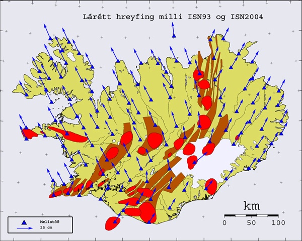
By comparing network surveys from the years 1993 and 2004 shows clear tectonic movements. The North-American plate is moving northwest while the Eurasian plate is moving northeast. In total the horizontal east-west movement is around 2 cm per year. The red areas indicate volcanic activity (Source: http://www.lmi.is/um-landmaelingar/landshnitakerfi/grunnstodvanet/isn-2004/).
A.2 Historical Context
Iceland was settled by the Norse from Scandinavia via the British isle in the late 9th century. However, in the Book of settlements (Landnámabók)it is stated that the island had been settled by Irish monks called Papar before the arrival of the Norse. No archaeological findings support this statement but it is still considered a possibility.
The settlement of Iceland in the 9th and 10th centuries AD was based on animal husbandry, with a main emphasis on dairy cattle but also sheep. For this activity, land resources that offered a range of grazing and fodder production opportunities were required to sustain farmsteads. Altogether 437 main settlements are described in Landnámabók and there off 54 were women.
With the establishment of Althing (Parlaiment) in 930 the Icelandic commonwealth was founded which lasted until 1262 when Iceland became a part of the Norwegian kingdom through intrigue and civil war that had plagued the country since 1220. Iceland was a part of the Norwegian kingdom and through it became a part of the Kalmar union 1397. After the union was abolished in 1523 Iceland was again part of the Danish-Norwegian crown until 1662 but then a Danish monarchy was declared in Iceland. The Danish monarchy lasted until 1848 due to reforms and increased demands for civil rights mainly in Denmark
The catholic church was for a long time the only institution in Iceland or from 1096 to 1550. The Church became the biggest landowner and collector of taxes. The majority of the population was poor and had to live in tenancy on various number of estates and small cottages. After the abolishment of the catholic church with the execution of the last catholic bishop by the order of the Danish king the society became even more divided by class and the almost all of the farmers were tenants or 97,5% in 1787. The main landowners were the church 31% the crown 20% and private landowners class the Icelandic elite 49% in 1709-1714. The system didn’t encourage any reforms are new economics, such as improvement for fisheries or agriculture. Most reforms experimented by the Danish crown failed and this proofed fatal in the Laki eruption 1783-84 which was followed by the blue haze causing widespread famine throughout Iceland with population decline from 55.000 to 38.500 in 4 years
The latter half of the 19th century is remembered as the time of the fight for independence - not with weapons – but in parliament with words and legal claims that stated that Iceland never became a part of Denmark or the Danish crown. Iceland also rejected an offer to gain a colonial status within the Danish monarch and further restored Alþingi in 1845. In 1874 the Icelandic people received their own constitution as a 1000-year settlement anniversary present from the Danish monarch. In 1918 Iceland gained sovereignty and 25 years later full independence in the year of 1944 as the republic of Iceland.
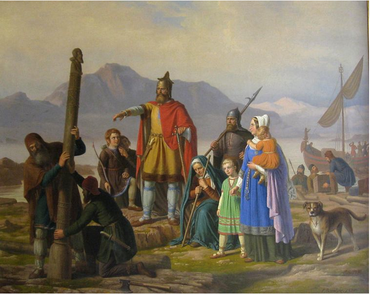
Painting by Johan Peter Raadsig of Ingólfur Arnarson and Hallveig Fróðadóttir, the first settlers in Iceland, erecting the high seat pillars on their new land, Reykjavík.
A.3 Current Political and Administrative Structures
Iceland is not a member of the EU but is a member of the EEA and part of the Schengen agreement. It has no armed forces but is a member of NATO. American forces were stationed in Iceland continuously since WWII until September 2006.
Iceland is a representative democracy and a parliamentary republic. The parliament Alþingi is located in the capital Reykjavík and has 63 members, elected for a term of four years. The president is elected by popular vote, also for a term of four years.
There are two administrative levels found in Iceland, national and municipal. Now there are 74 municipalities in Iceland of all sizes and shapes. The 10 most populated have almost 80% of the total population in Iceland. The 10 least populated account for only 0.25% of the total population, or a sum of 865 inhabitants.
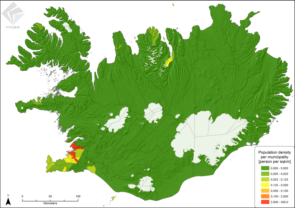
Iceland is sparcely populated country with the highest population density in the southwest (Map made by Registers Iceland 11/11/2015).
A.4 Historical Outline of Cadastral System
archaeological and environmental data, suggest that inherent land attributes played a significant role in the way the landscape was carved up during the period of initial settlement and colonization of Iceland. The earliest available sources post-date the settlement period, but they indicate that permanent boundaries, such as rivers and gorges, were deciding factors in the initial partitioning process. Subsequent partitioning suggests that the initial landowner may have made an effort to ensure the viability of specialized livestock production within the area by allocating some of the best land to the second largest settlements while some of the larger had more diverse land quality.
Formal registration of rights to land started in 1096 with the tithe laws promoted by first Bishop Gissur Ísleifsson. These laws needed public inventory for property and land valuation as the tax was calculated from both moveable and immovable properties values. The church became a big landowner and kept registries for the church estates and monasteries and their various holdings in cadasters known as Máldagar. These lists were far from being complete and sometimes they just copied from century to century. After the abolishment of the Catholic church in 1550 the Danish king became the head of the church and wanted to know how much belonged to the church and some minor reforms were made. In 1641 the Bishop in Skálholt Brynjólfur Sveinsson started create a detailed cadaster for the estates belonging to Skálholt and the episcopal see. However, one of the most detailed land registers in Europe was created in 1709-1714 when the Danish crown send two Icelandic officials Árni Magnússon and Páll Vídalín both working for the crown on a collect information about all estates and farmsteads in Iceland, furthermore they collected land value, rent, number of livestock, holdings, obligation of the tenants, and all extra resources. Unfortunately, this register was not published until two centuries later and was mostly forgotten and the reforms it was supposed support failed to materialize.
After the Laki eruption and the following famine and economic crisis more similar cadasters were made one in 1801 and another in 1847 as well as 1861 But there was no attempt identify the boundaries between estates unless there was a legal dispute until 1880 when the first coherent attempts to geographically delimitate land were made by laws in 1880 that stipulated every land owner to describe the extent of his land ownership with words - so called boundary description - referring place names and natural features:
Corner monument: The ruin close to Heiðrimakelda-spring, south of Oddholtsmúla-mound; from where there is a line of sight, west to Héðinslækjabotnar-hollow, from here the boundary follows Héðinslækur-creek, and then Höskuldslækur-creek to the Hvítá-river. To east of the above mentioned ruin close to Heiðrimakelda-spring the boundaries run south to Þverkelda-spring which runs from Galtatjörn-pond … (Boundary description of Arnarbæli, Grímsnes, National Archives of Iceland, 1884).
This law was revised in 1919 almost unchanged and has governed how legal boundaries are located in rural areas. However, law on land surveying and cadastral registration in Reykjavík city were set in 1914 and identical law in Akureyri city in 1951. These law enforced the implementation of cadastral system in these two largest cities in Iceland at the time. Later in 1998, new planning and building law were set that in fact enforced every municipality to maintain cadastral registration of lands and lots within their jurisdiction.
Revised planning law came into effect 1st of January 2011 stating that Registers Iceland were responsible for maintaining a cadastral map (landeignaskrá) for whole Iceland, replacing the earlier role of the municipalities.
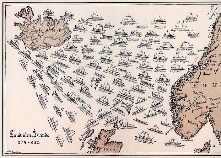
The Book of settlement describes over 400 settlers that came over the ocean from various parts of northern-Europe, most notable Scandinavia and the British Isles.
B. Institutional Framework
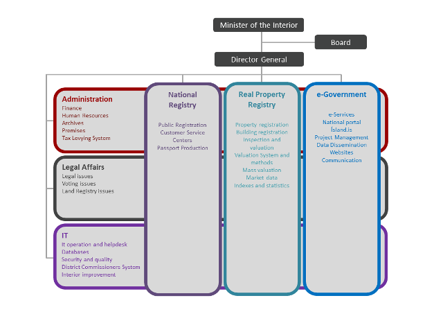
B.1 Government Organizations
Registers Iceland, under the jurisdiction of ministry of the interior, is responsible for operating the land and cadastral registration as part of the RealProperty Database in cooperation with associated authority:
- Land register officers register within the land registry section (Þinglýsingarhluti)
- Municipalities register within the cadstral section (Stofnhluti og Landeignaskrá)
In general Registers Iceland registers a range of information on Iceland's residents and real properties, and provides related services such as assessment, allowing electronic access to the registers and issuing certificates, passports, ID cards and the electronic ID: "Icekey". Registers Iceland is also responsible for the operation and development of the national portal Island.is.Sale prices and methods of payment from every sale contract are collected into the Land Registry Database and used for the calculation of economic indicators, such as the real estate price index.
B.2 Private Sector Involvement
Given the resources currently available, close cooperation with the private sector is regarded as the most efficient way in which to carry out cadastral survey in Iceland. Registers Iceland, along with individual municipalities, have in recent years cooperated closely with private sector companies in generating the base cadastral data required for creating a spatial Cadastre and developing tools and interfaces for accessing these data.
Most municipalities buy most of the survey work, design and map making of off private engineering- and or architectural companies. Hence, a big part of spatial cadastral data assembled by Registers Iceland is originated in the private sector.
B.3 Professional Organization or Association
There is currently no professional organization or association for cadastral surveyors in Iceland.
B.4 Licensing
There is currently no licensing system for cadastral surveying professionals, or any surveying professional for that matter. 'Cadastral surveyor' is not even a registered profession in Iceland. Surveying is carried out by a diverse range of people, some working for engineering- or design companies and some working for the government or municipalities. There are some individual private 'surveyors' active, despite the lack of available certificate of qualification. There are at present no requirements imposed upon how cadastral surveys are undertaken.
B.5 Education
There is no formal cadastral surveying education available in the Icelandic school system, except for basic introduction of survey methodology as a part of other courses at two of our Universities' departments of natural science and engineering.
Educated surveyors in the country are mostly educated in countries like Norway, Sweden, Denmark, Netherlands and Germany.
C. Cadastral System
C.1 Purpose of Cadastral System
Icelandic cadastral information have a legal role in the land market, a fiscal role in land evaluation and taxation - which is based on the evaluation - as well as being used for regional planning. The need for a uniform multi-purpose cadastre that covers the whole of the country is ever increasing, alongside a rising demand for digital cadastral information in plannig, land management and such. It is important that rural areas become more integral part of the cadastral system, as we dont have good enough base data for land evaluation in rural areas as it is. When we have good enough data, the fiscal role of the system will increase.
C.2 Types of Cadastral System
There is one uniform cadastral system for the whole country operated by the Registers Iceland and maintained by municipalities.
Most larger municipalities have good quality cadastral map of their urban areas but information on boundaries in rural Iceland are far from being complete.
Infomal or illegal settlements have not caused any real problem to this day.
C.3 Cadastral Concept
There is no specific law covering cadastral registration in Iceland but the concept is partly covered within the law on real property registration and valuation.
Work is in process to make cadastral amendment to current law environment. These amendments will reflect recent development in cadastral registration within Registers Iceland which was assigned to the role with new planning law 1st of January 2011.
The model is as follows:
- A real property object is the center of attention within the land registry (connecting it to owners) and within the cadastral (type, planned use, registered area, surveyed boundaries etc.)
- A real property is connected to at least one land object. A condominium is when more than one real property object is related to a land object.
- Land object can consist of one or more cadastral parcels, either fully owned by the land object in question or in joint ownership with other nearby land objects within the same municipality. A land object is either regarded as having 'complete' extent mapped or 'incomplete' - based on association to mapped cadastral parcels.
- Cadastral parcel is delimited with cadastral boundaries. The parcel is either regarded as 'complete' or 'incomplete' - refering if its potential inner boundaries/islands are completely mapped.
- Cadastral boundary consist of two boundary nodes (start/end), unlimited number of intermediate survey points and is related to exactly two cadastral parcels. Cadastral boundary is regarded as general, fixed or dynamic/fuzzy.
- Boundary node is related to exactly one survey point. Boundary node can be regarded as general, fixed or dynamic/fuzzy.
- Survey point originates in one specific survey document that can include unlimited amount of surveys and survey points.
C.4 Content of Cadastral System
In total around 202.775 real properties are registered within the real property database (RI, April 2019).
There are 108.565land objects registered (RI, April 2019), 90.301 can also be regarded as real property (1:1 relationship) while 18.264 are part of a condominium (1:M) (RI, april 2019)
Approximately 52,8% land objects are delimitated within the cadastral map while 95,9% can be located with a point promised to be within one of its parcels (RI, April 2019).
Cadastral documents are kept locally by either municipality or/and land registry office. Documents that include subdivision or merger of already defined land objects are kept by municipalities, while legal documents that need owner signature (e.g. boundary descriptions, boundary map etc.) are kept at land registry offices.
D. Cadastral Mapping
D.1 Cadastral Map
An official cadastral index map is now available for whole Iceland, containing mapped cadastral parcels by Registers Ieland.
http://geo.skra.is/landeignaskra
The same data can be downloaded free of charge at http://www.skra.is/fasteignaskra/nidurhalsthjonusta/. The same data is also accessible through ELF services.
Still one has to find original cadastral survey document to get information of the formal extent of specific land object.
Registers Iceland published in 2015 guidelines to standardise the content of cadastral survey documents.
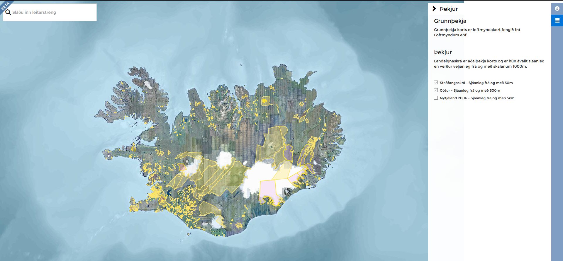
Online cadastral map, beta version, is now available at geo.skra.is/landeignaskra
D.2 Example of a Cadastral Map
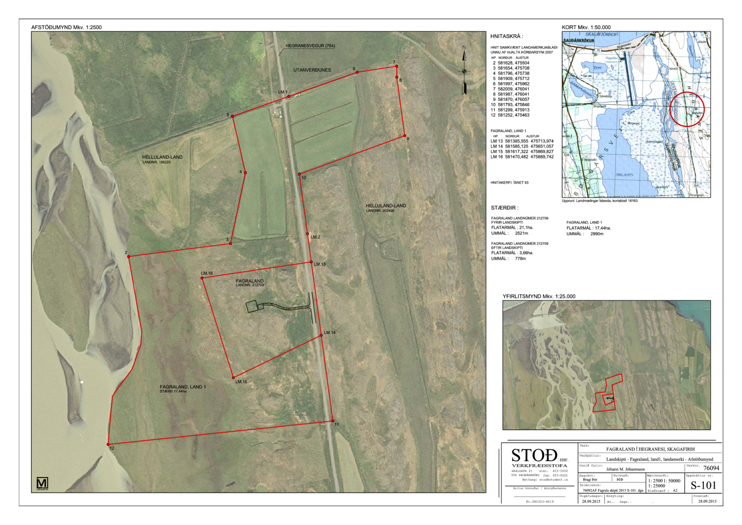
Cadastral map for subdivision of Fagraland in Hegranes, Skagafjörður.
D.3 Role of Cadastral Layer in SDI
The cadastral map data was published freely available as an open source data in the spring 2016. It can both be displayed and downloaded at Registers Iceland website: http://www.skra.is.
E. Reform Issues
E.1 Cadastral Issues
- Reform on legislation and regulation. No cadastral law is in place in Iceland. There is urgent need for legal amendments to support further activities in surveying and registration of cadastral boundaries. [2018: we have been in contact with the ministry but no news yet of possible law amendments.]
- Cadastral mapping – collecting boundary data. Several municipalities have collected cadastral boundaries within their LADM that has not yet been included in the cadastral map maintained by Registers Iceland. In total this could amount for 30-40 thousand parcels. [2018: We have collected the extent of approximately 35.000 parcels in cooperation with three municipalities. Work is still ongoing and will hopefully be completed in 2018.
E.2 Current Initiatives
At present we are working on points 1 and 2 mentioned above - thus collecting cadastral data from municipalities and putting pressure on our ministry for law amendments regarding cadastral work.
F. References
Network survey comparison. Landmælingar Íslands. http://www.lmi.is/um-landmaelingar/landshnitakerfi/grunnstodvanet/isn-2004/
Part 2: Cadastral Principles and Statistics
1. Cadastral Principles
1.1 Type of registration system |
|
title registration
deeds registration |
1.2 Legal requirement for registration of land ownership |
|
compulsory
optional |
1.4 Approach for establishment of cadastral records |
|
systematic
sporadic both, systematic and sporadic all properties already registered |
2. Cadastral Statistics
2.1 Population |
358,944 |
2.2a Population distribution: percentage of population living in urban areas |
94 |
2.2b Population distribution: percentage of population living in rural areas |
6 |
2.3 Number of land parcels |
108,565 |
--- Number of land parcels per 1 million population |
302,400 |
2.4 Number of registered strata titles/condominium units |
18,264 |
--- Number of strata titles/condominium units per 1 million population |
50,800 |
2.5 Legal status of land parcels in URBAN areas: |
|
percentage of parcels that are properly registered and surveyed |
90 |
percentage of parcels that are legally occupied, but not registered or surveyed |
0 |
percentage of parcels that are informally occupied without legal title |
0 |
2.6 Legal status of land parcels in RURAL areas: |
|
percentage of parcels that are properly registered and surveyed |
10 |
percentage of parcels that are legally occupied, but not registered or surveyed |
0 |
percentage of parcels that are informally occupied without legal title |
0 |
2.7 Number of active professional land surveyors |
0 |
2.8 Proportion of time that active professional land surveyors commit for cadastral matters (%) |
0 |
--- Approx. full-time equivalent of land surveyors committed to cadastral matters |
0 |
2.9 Number of active lawyers/solicitors |
0 |
2.10 Proportion of time that active lawyers/solicitors commit for cadastral matters (%) |
0 |
--- Approx. full-time equivalent of active lawyers/solicitors committed to cadastral matters |
0 |