Jamaica
 |
|
Contact person for provided information:
Dr Glendon G. Newsome
Associate Professor
Land Surveying & Geographic Information Sciences Division
The University of Technology, Jamaica
gnewsome@utech.edu.jm
Part 1: Country Report
A. Country Context
A.1 Geographical Context
At a latitude of 18 degrees north and a longitude of 77 degrees west, is the small Caribbean island of Jamaica situated south of Cuba and west of Haiti. Jamaica is approximately 235km long and is between 35km to 85km wide, with a total area of 10,991 km2. Jamaica is the third largest Caribbean island, and it is the home of approximately 3 million inhabitants spread across fourteen (14) parishes, contained in three (3) counties. According to a survey conducted by the World Bank (2002 57% of Jamaica’s population resides in urban areas such as Kingston (the Capital), Spanish Town (former Capital) and Portmore, a municipality, while the other 43% lives in the more rural parts of the island. Jamaica has four (4) mountain ranges which are the Blue Mountains, the John Crow Mountains, Dry Harbour Mountains, and the Mocho Mountains. Its highest point is the Blue Mountains at 2256 meters. The three most common land uses in Jamaica are forestry, agriculture, and human settlements. Agriculture and forestry account for approximately half of the land use in Jamaica, while residential settlements in both urban and rural areas occupy less than half of the land area. Industrial, commercial, mining and wetlands utilise the remaining small portion of the lands. Jamaica has a variety of forests, including lower montane mist forest, montane mist forest, dry limestone forest, wet limestone forest, mangrove woodland, herbaceous swamp, and marsh forest. The Blue and John Crow Mountains are a national park. The park covers 495.2 km², is situated in the eastern end of the island and is a recently declared UNESCO Natural World Heritage site.
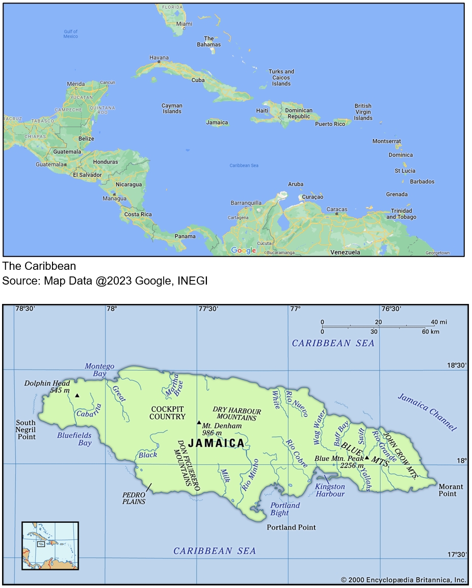
The Carribean and Jamaica
A.2 Historical Context
The Tainos are thought to have been Jamaica's first settlers since 2,500 years ago. Until 1949, when Christopher Columbus found the island and appointed the island’s name of “Xaymaca,” which means ‘Land of Wood and Water, ’the Tainos lived in peace and quiet. By the early sixteenth (16th) century, the Spaniards had colonized the island, exterminated the Tainos, and replaced them with African enslaved people. On May 10 1655, the English led by Admiral William Penn and General Robert Venables attacked Jamaica and captured the island from the Spaniards. The English invested in growing various crops that could be sold to England, and to grow the crops, they continued the forced use of enslaved Africans.
On January 1, 1808 the Abolition Bill was passed and the slave trade was abolished. However, even though the slave trade was abolished, and the original plantation owners had left the island, new owners were running the plantations and the original system of slavery was maintained. In October 1865, the Morant Bay Rebellion led by Paul Bogle erupted where numerous European settlers were killed, and as a result, Paul Bogle and Sir William Gordon (both now Jamaica’s National Heroes), were killed along with hundreds of people by the Governor Edward John Eyre. As a result of Eyrie’s actions, he was recalled to England and in succeeding years saw the recovery and development of Jamaica into a Sovereign State.
Roads, bridges, and railways (government ownership of the railroads began in 1845) were built as well as cable connectivity with Europe (1859) was established. Kingston became the island's capital, replacing Spanish Town in 1872. Slavery ended in 1834 and Jamaica was granted independence from Britain on August 6, 1962, when the Jamaican Constitution took effect. The Jamaican Constitution of 1962 is the country’s most important legal constitution, guaranteeing the freedom, rights and advantages of all Jamaican citizens. It symbolizes the country’s political independence as a nation state and is the foundation of the island’s legal systems and institutions to this day.
A.3 Current Political and Administrative Structures
Influenced by colonization Jamaica adopted the Constitutional Monarchy style of governance with the British Monarch as the head of state who is represented by a Governor General. The constitution was influenced by a British system of government, with a parliamentary democracy based on the British Westminster model, which allows citizens every five (5) years, to elect a political party they wish to represent them. There are two major political parties, the People's National Party (PNP) and the Jamaica Labour Party (JLP). Under the Constitutional Monarchy style of governance, you have three branches of government, the executive, legislature, and judiciary. The role of the executive, also known as the cabinet, is to initiate and guide policy making of the country. The legislature or parliament is responsible for enacting and amending laws and it is made up of the lower and upper houses. The upper house or the senate consist of twenty-one (21) members and the lower house, or the house of representatives consists of sixty-three (63) members, who are the elected representative of their constituency, located in one of the country's fourteen parishes. The Senate is made up of 21 senators nominated by the Governor-General, 13 of whom are appointed on the Prime Minister's advice and eight on the Leader of the Opposition's advice. The Senate's President is elected by its members. The Speaker of the House is chosen by the members of the House of Representatives. The Governor-General appoints the Prime Minister, who is generally the person most likely to command the support of the majority of House of Representatives members. Local governance is handled by 12 parish councils and a statutory company that manages the Kingston and St. Andrew (KSAC) districts as well as the Municipality of Portmore, in addition to the national governing organizations. A bill is a draft act of parliament and no bill may become law unless it is passed by both Houses of Parliament and gets the Governor-official General’s assent. The third branch of government is the judiciary; this is the section of the government that administers justice. This is done through a network of courts. All the arms of the government work hand in hand to maintain stability in the country.
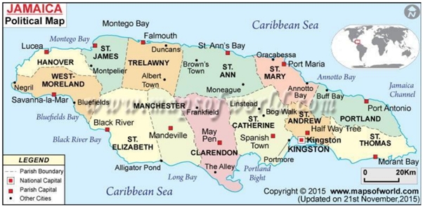
Jamaica - Political Map
A.4 Historical Outline of Cadastral System
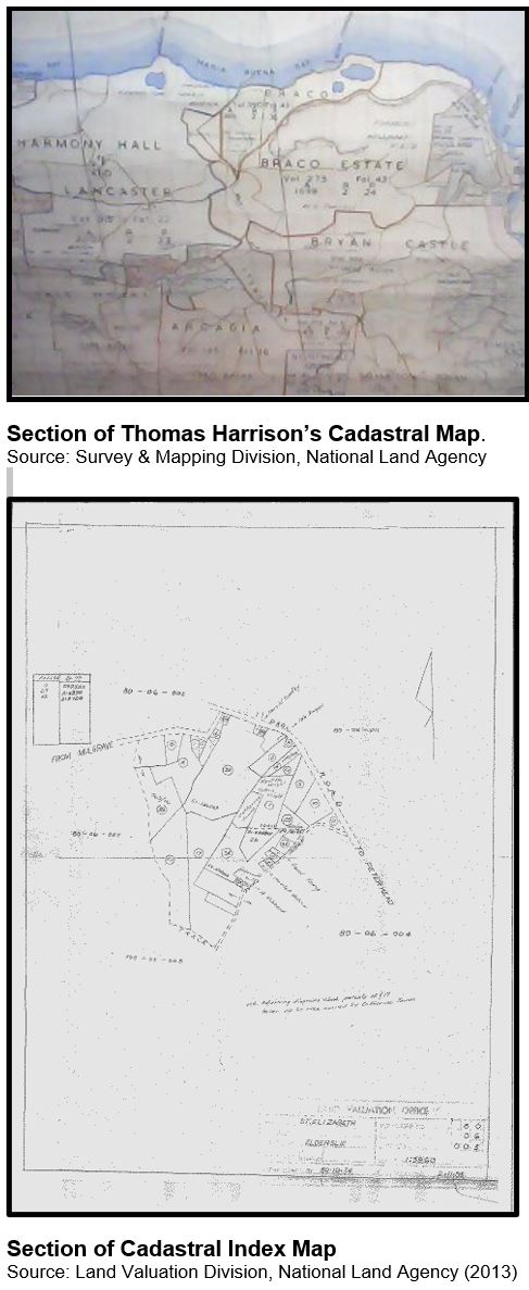
Land was distributed among ordinary citizens in Jamaica for the first time during the 1830’s. The Registration of Titles Act was passed 59 years later (1889), in the form of a Torrens System (attributed to Robert Torrens of Australia) of land registration. The Torrens system is based on three principles, the curtain, mirror, and assurance, and this system provides a title of ownership, all boundaries of the parcel are identified and precisely surveyed, and an assurance fund is provided, to make available compensation, in a case where a mistake made by the registrar of title, to cover cost to the owner (Ramdatt, Shaw, and Blake 1997). The Torrens system offers: state guarantee of the title, fixed boundary identification, precise survey of boundary. In the late 1800’s a cadastral index map (Thomas Harrison) of the island was prepared in thirty-three (33) sheets using plats, plans and verbal descriptions.
The system of Land Registration is voluntary/sporadic. The Cadastral Index lacked maintenance due to institutional constraints and lack of financing. An out of date, inaccurate, inconsistent cadastral index made way for: dual registration, hampering of government’s ability to effectively manage its natural resources, stymied land development and causing a lengthy registration process (Ramdatt, Shaw, and Blake 1997). Before 1889, a deeds registration system was employed with the Island Record Office being the only place where land could be registered. (Munsung and Knight 2014).
The Inter-American Development Bank (IDB) funded a land titling project in Jamaica to: expand and increase the rate of land registration; technical, legal and infrastructural strengthening; establishment of a land information system; and the construction of a Cadastral Index Map (Ramdatt, Shaw, and Blake 1997).
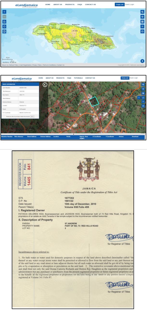
The initial purpose of the cadastral index was fiscal i.e., for the collection of land taxes from citizens, rather than legal, as such the parcels were not accurate in terms of this shape, size, and location. Even though a legal purpose was not the basis of developing the cadastral index, it was still utilized in the registration process. Land registration at this time in Jamaica is voluntary and of 874,609 parcels in Jamaica and 546,440 or 62.48% are registered under the Registration of Titles Act (National Land Agency, 2023). This coupled with the fact that transactions related to land took weeks or even months before they could be completed, the Jamaican government decided to merge all the departments that dealt with land registration and titling to create the National Land Agency in 2001. The main mission of the National Land Agency was to create a digital database for land records, to decrease the time it takes to deal with land registration matters. The digitization of majority of the country's land records was completed by 2004. With this new digital environment, a “Parcel Data Management System (PDMS), with ArcGIS at its core, was linked to Aumentum Registry and enabled the visualization of the records in their locational context” was established (Jones, 2017). In 2010 a public-private partnership between the NLA and the Guardian Group insurance company made the cadastral index what it is today. The partnership enables the agency the opportunity to provide spatial data and parcel-related information to the public by creating a map, iMap Jamaica (now eLandJamaica). The procedure engaged to build the map: a) Scan enclosure maps and after enhancing lines; b) Vectorizing using ArcScan and build topology; c) Geo-reference parcel map and raster image (basemap); d) Add valuation number, volume and folio numbers (where applicable), lot number and civic address to each polygon; e) Quality check coverage for graphical and attribute accuracy; and f) Enter enclosure information in ArcStorm database. This map is beneficial to both parties, as it allows the NLA to provide its customers with information regarding a parcel such as its street address, the land valuation number, the title reference (volume and folio) number, if the parcel is registered. The map is interactive as one is able to zoom in and out and change the layer being displayed. Though eLandJamaica, is referred to as a map, the cadastral index is still the basis of the map. However as new parcels are surveyed, a more accurate digital cadastral parcel layer is being constructed from digitizing deposited plans, single parcel registered and unregistered plans, as well as coordinate geometry re-construction of parcel boundaries, in order to build out a national digital cadastral map, which is to support future electronic titling.
B. Institutional Framework
B.1 Government Organizations
The National Land Agency (NLA) of Jamaica is the government agency that is responsible for land administration and registration in Jamaica. The NLA is a merger between four (4) government departments namely: the Lands Department; the Office of Titles; the Survey Department; and the Land Valuation Office. Land registration and cadastral surveying of state land are done and managed by the National Land Agency which is an Executive Agency that falls under the Ministry of Economic Growth and Job Creation. This government run agency has ten (10) divisions to ensure an efficient workflow. These divisions are: Land Titles; Surveys & Mapping; Land Valuation Division; Estate Management; Adjudication Services; Land Administration & Management; Corporate Service; Corporate Legal Services; Business Services and Information and Communications Technology. The agency is headed by a Chief
Executive Officer (CEO), whilst, each division is supervised by a Director. The agency is constituted by an executive agency act and also governed by six (6) other pieces of legislation, namely: Registration of Titles Act 1889; Registration (Strata Titles) Act 1969; Land Valuation Act 1957; Land Surveyors Act 1944; Crown Property (Vesting) Act 1960; and Land Acquisition Act 1947. The NLA was established due to the result of the Public Sector Modernisation Programme of the Government of Jamaica which brings together the core land information functions of Government under one roof.
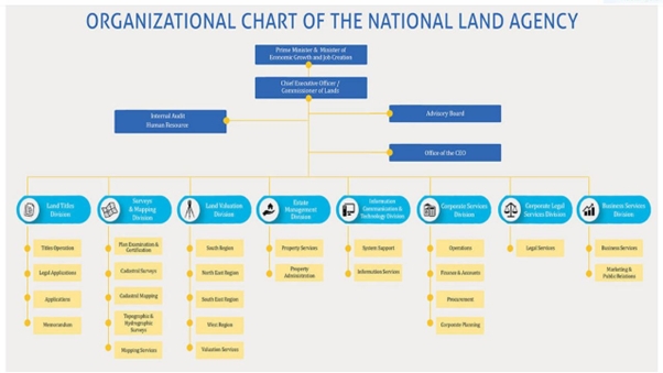
Organisational Chart of the National Land Agency, Source: NLA Website (https://www.nla.gov.jm/content/organzational-chart)
B.2 Private Sector Involvement
In terms of land registration and cadastral surveying, the private sector is more involved in the surveying aspect of the process. In Jamaica, the private sector conducts the majority of the surveys. Since land registration is optional, when a person wants to register their land, they typically engage a private sector surveyor to survey the parcel. The surveyor then submits the required plans to the NLA's Surveys & Mapping division for examination and certification. Additionally, the NLA has been employing the expertise of numerous surveyors from the private sector since the launch of a new Systematic Land Registration (SLR) program.
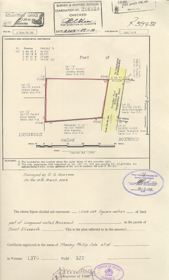
Cadastral Plan Annexed to a Certificate of Title (Source: NLA Land Titles Division)
B.3 Professional Organization or Association
The Land Surveyors Association of Jamaica is the professional organization for surveyors in the country. The association was established in 1928 with the aim of “protecting the interest of the public and land related matters” (LSAJ Website https://www.lsaj.com/about-us). The association has nine (9) council members (headed by a President) one hundred and thirteen (113) members and some forty-five (45) associate members.
The Land Surveyors Board maintains a list of professional surveyors that are certified/commissioned in accordance with Section 11 (1) (a) of the Land Surveyors Act. There are currently one hundred and eighteen (118) Commissioned Land Surveyors in Jamaica.

B.4 Licensing
The Land Surveyors Board of Jamaica is the organization responsible for the issuance of surveying licences. Before a surveying license can be issued by the board one must meet certain requirements. After completing a bachelor’s degree in Land Surveying & Geographic Information Sciences from the University of Technology or hold any other qualifications approved by the board, one has to become a trainee or student surveyor. As a student surveyor aiming to become commissioned, it is required that the student/attachee attached/interned to a Commissioned Land Surveyor (CLS) for at least one (1) year before being eligible for sitting the board administered examination. There are two components to the examination to become a commissioned land surveyor, a practical component and an oral examination. The attachment involves completing and recording the details of three (3) different types of surveys (cadastral, topographic and engineering), while attached to a commissioned surveyor. After completing the attachment, the student surveyor will then be recommended by his/her principal to the board for the sitting of the examination. Upon passing the examination, the students make an application to the board, to be commissioned. Surveyors are required to have a practising certificate, which is issued by the board annually, upon proof of completion on a minimum of twelve (12) hours of Continuous Professional Development.
B.5 Education
The Faculty of the Built Environment, University of Technology, Jamaica offers two programs that train individuals to become surveyors. There is a bachelor’s degree program and an associate degree program. The undergraduate degree is a four-year program whereby, at the end of which, students are awarded a Bachelor of Sciences Degree in Land Surveying & Geographical Information Sciences. The entry requirements for the degree are five CSEC passes or its equivalent, two of these passes should be in Mathematics and English Language and the remaining three should be from among the likes of: geography, physics, technical drawing, etc. A student who has completed the two-year associate's degree program, can obtain advanced matriculation into the second year of the 4-year degree program. The entry requirements for this program are four (4) CSEC passes or the equivalent, which should include Mathematics, English language, and two (2) other university-approved subjects. In recent years roughly fifteen students are graduating from the surveying programs annually. The two programmes cover a wide range of topics including: Plane/Field Surveying, Geographic Information Sciences/Systems (GIS), Geodesy, Engineering Surveying, Remote Sensing, Photogrammetry and Surveying Instrumentation. The last (2022) graduating class had 14 graduates from the four-year degree program and four graduates from the associate degree course of study.

Faculty of the Built Environment, University of Technology, Jamaica.
C. Cadastral System
C.1 Purpose of Cadastral System
Initially, the cadastral system was established for fiscal purposes, i.e., for land valuation and tax collection. As it was a cadastral index that was what was established, the actual positions on ground were not viewed as important at the time as they only needed positions of the boundaries so that the land can be valued for taxes and not to show ownership. However, the system has evolved to a stage where it has both fiscal and legal purposes. The Jamaican cadastral system has both the legal components and the map component located in one register, which can be accessed via the elandJamaica website.
This map shows all registered and unregistered parcels of the island, and it shows, the legal situation of the land, as land titles and other ownership information are accessible through the database.
The Jamaican Cadastral System is based on Torren's land registration system, which was implemented in 1869, and deeds registration, which was implemented in 1879, with the fiscal cadastre playing a supporting role since the 1970s. Because the procedure is voluntary, registration of land is intermittent. Operations on both registered and unregistered land are carried out through a deed system, of which only some are documented at an Island Records Office, which is independent of the Land Registry, while cadastral surveys are carried out in accordance with a fixed boundary system (Newsome, 2023).
C.2 Types of Cadastral System
There is only a single cadastral system that encompasses all the parcels of the island. So, all registered and unregistered, private and public-owned lands, all forest areas, and national parks records are held in this single system. Squatter settlements are common occurrences on unoccupied parcels around the island. Approximately 20% of Jamaican citizens have occupied around 700 squatter settlements scattered about the island (Robinson, 2022).
Since land registration is voluntary, both registered and unregistered parcel makes up the cadastral system. In an effort to increase the number of persons holding registered titles to land, the Government of Jamaica in the year 2000, launched a pilot of a Land Administration and Management Programme, which was geared towards assisting individuals with acquiring certificates of titles to land. This was the first introduction to systematic land registration. However, it was somewhat unsuccessful as many individuals did not understand the system and coupled with scepticism, there was a lack of the required level of participation by holders of land. In 2020 a new method of systematic land registration was introduced, where the government has been providing property owners with certificates of title and allowing them to pay over time. What happens is that a caveat is registered against the title until it is fully paid for, after full payment, the caveat is removed and the person’s whose name is on the registered title becomes the freehold owner of the property.
C.3 Cadastral Concept
The country operates under the Torrens system and all land registration and other land records are maintained in the cadastral system which comprises of a Cadastre or Registry of land information and a Land Registry or Legal Register. Before the advent of the NLA, in 2001, all information related to land titling and registration were hardcopy documents. In 2004 majority of these documents, were scanned and uploaded to a digital database and from thereon digital records were kept for all land related matters. Once a registered title is approved and issued for a parcel, all information related to ownership is recorded on this title, which is accompanied by a cadastral plan, which depicts the parcel boundaries. This information is available online via elandJamaica, which is accessible by the public.
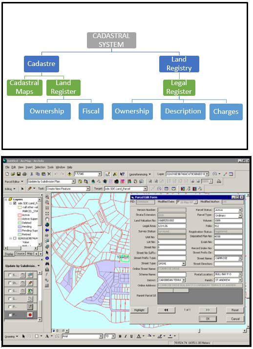
C.4 Content of Cadastral System
The cadastral system is the source of all information on land holdings and land use. It is constituted on the one hand by the records that make up a Cadastre and on the other the Land Registry. The textual record or register of the names and rights of owners is what is known as a land register, which is supported by a Cadastral Map/Index, as well as the assessed value of the land. The Land Registry contains information on the legal owners of land and a detailed boundary description, provided through plans and maps, depicting each parcel of land. Land rights are acquired by Jamaicans through inheritance, purchase, leasing, familial relationships, and squatting.
The system is maintained in the back office through a Parcel Data Management System (PDMS). Employees with the required Land Registration System access can search, view, browse, edit, update, and exchange parcel information created in Parcel Data Management System as well as browse related documents such as: Certificates of Title, Deposited Plans, Strata Plans, Survey Plans, Caveats, and Lodgments related to a parcel. The cadastral system is moving towards being multipurpose, one which shows and includes ownership, description of land, charges to land, the unimproved value of land and in the future, other attributes (Newsome, 2023).
Source: Samuels (2008)
D. Cadastral Mapping
D.1 Cadastral Map
What is currently referred to as a cadastral map for Jamaica is not technically a map but rather an index. This is so because the parcels are inaccurate in terms of their shape, size, and position on the ground, as the majority of this information was collected by Land Valuation Surveyors in the 1970s when an all island campaign was conducted by the then Land Valuation Department to build out a Fiscal Cadastre. The parcels were not being surveyed, but rather sketches of groups (enclosures) of parcels were made, with an estimate of the size of the parcels.
However, as parcels of land are surveyed and the plans or maps are submitted to the NLA for certification, they are being used to update the index, to reflect the accurate location, shape, and size of the parcel.
Hundreds of thousands of parcels have been compiled by the agency in a survey accurate form, as they transition out of a cadastral index into a Cadastral Map. This is achieved by retrieving certified survey plans from the records, computing or digitizing their boundary notes in the Terra Model Coordinate Geometry software or ArcGIS, respectively, and geo-referencing single or blocks of parcels using Spatial Adjustment in ArcGIS or using Global Navigation Satellite System (GNSS) surveying techniques in the field, where necessary. This is in an effort to create a National Digital Cadastral Map (NDCM) of the island (Henry, 2022).
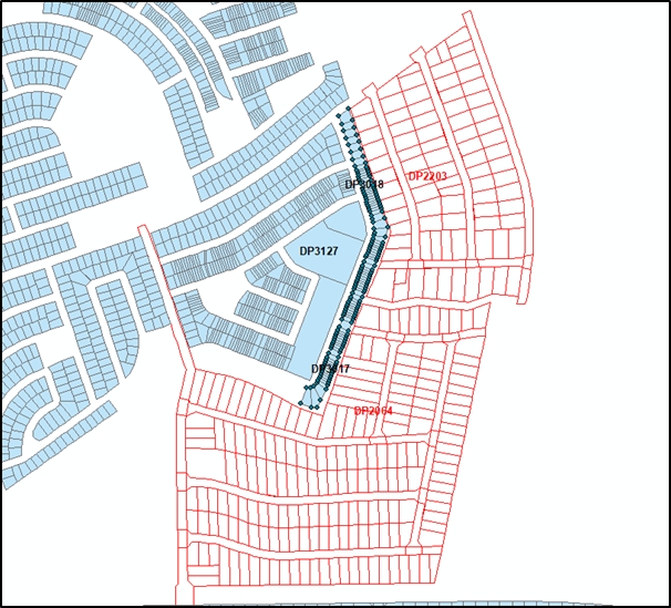
Compilation of NLA Certified Plans/Maps (Source: NLA)
D.2 Example of a Cadastral Map
All parcel information compiled and georeferenced for the purpose of the NDCM is made available via a web portal named Cadastral Map Application.
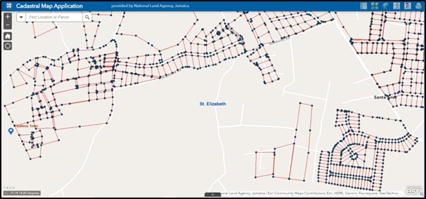
National Digital Cadastral Map Application Source:
D.3 Role of Cadastral Layer in SDI
Other than for land-related purposes of the cadastral layer, eLandJamaica, can be used for other tasks such as navigation. With the interactive map, eLandJamaica, the user can change the layers that are seen on the map, so an imagery layer can be enabled which gives a top-down view of the island and allows the user to locate places and determine addresses. The map can also be used in planning and development in that developers can always use the map to identify parcels that they may have in interest in acquiring and determine if its location is suitable for development in terms of the proximity to schools, health facilities, urban centers, etc.
Notwithstanding, not having a completed cadastral map, cadastral information on parcels are used for the purpose of valuation and taxation by the government. Land Valuation System (LVS), the first computerized system for the government of Jamaica, which was developed by Fiscal Services Limited (FSL) of Jamaica, now e-Government Jamaica (eGovJa), an entity within the Ministry of Science, Technology, Energy and Mining (MSTEM), responsible for the implementation of ICT projects within the Government service, is used by the Land Valuation Division (LVD) of the NLA to maintain a valuation roll, to support the taxation of every property, appraise all privately owned properties in Jamaica for the purposes of property taxation, as well as properties owned, leased or to be acquired by government, and records changes in property information.
E. Reform Issues
E.1 Cadastral Issues
Cadastral Issues for Jamaica include:
- The lack of a complete cadastral map of the island, which has serious implications for the legal registry, in that certificates of title are erroneously issued for lands already registered, giving rise to dual registration of land and conflicts over land ownership.
- The land registration process is lengthy.
- The cost of land registration is still too high for many landowners.
- The Cadastral System is not reflective of the true situation on the ground.
- The Cadastre and the land registry data, are held separately in PDMS and LRS respectively
- The spatial representation of parcels is predominantly a cadastral index rather than a cadastral map.
- The lack of efficient and appropriate parcel mapping strategies.
E.2 Current Initiatives
The NLA is currently actively updating the current cadastral index with the information needed to convert it to a cadastral map. The government is also taking the initiative to address the issue of time to process applications for a certificate of title, by implementing an electronic submission of applications and fee payments. To reduce the cost of the land tilting and registration process, the government initiative is to regulate the fees associated with land administration also with the new approach to systematic land administration, property owners are provided with land titles by the government, which they can pay back for it over time, rather than one huge payment before the title can be issued.
Other initiatives of the National Land Agency seek to continue business process reengineering and technical advancements to enhance operations in land registration, estate administration, surveys, and mapping. Raising public awareness, etc. The NLA is also working so that: 1. By March 2024, 20,000 additional Certificates of Title will be issued under Systematic Titling. 2. By 2025, electronic titling will be implemented. 3. Achieve a Customer Quality Index score of 90% by 2024. 4. Create half of the Digital Cadastral Map by 2024. 5. By 2024, establish a land bank in partnership with the Planning Institute of Jamaica (PIOJ) (National Land Agency, n.d.).
Systematic Land Registration (SLR) is being used to assist landowners who have been in open, undisturbed and undisputed possession of land for twelve years or more, to claim ownership of such land via the SLR process. SLR is the methodical and orderly registration of parcels of land in a designated area known as the Systematic Adjudication Area. Also NLA is now providing hosting infrastructure to persons who do not have the capacity or expertise to access spatial data, that allows them to access customized maps and data set in a secured environment.
F. References
Buisseret, D. J., Ferguson, James A., Bryan, Patrick and Black, Clinton V.Accessed November 20, 2022. Jamaica. Encyclopedia Britannica. https://www.britannica.com/place/Jamaica
Encyclopedia Britannica, Inc. 2000. Map of Jamaica. Accessed November 20, 2022. https://www.britannica.com/place/Jamaica
Henry, Charnele. 2022 “Progress in Development of National Digital Cadastral Map”. Jamaica Information Service, August 24, 2022. Accessed November 24, 2022 https://jis.gov.jm/progress-in-development-of-national-digital-cadastral-map/
Jones, Brent, 2017. “Digitally Transforming Cadastre in Jamaica”. GIM International. Accessed November 20, 2022. https://www.gim-international.com/content/article/digitally-transforming-cadastre-in-jamaica
Land Surveyors Association of Jamaica. 2016. Webpage. Accessed October 16, 2023. https://www.lsaj.com/about-us
Map of World. 2015. Jamaica. Accessed November 20, 2022. https://www.mapsofworld.com/jamaica/
National Land Agency. 2019. National Land Agency Strategic Business Plan 2022-2026 Final. Accessed November 20, 2022. https://nla.gov.jm/file/national-land-agency-strategic-business-plan-2022-2026-finalpdf
National Land Agency. 2019. Parcel Statistics. Accessed October 17, 2023. https://nla.gov.jm/content/parcel-statistics-0
Newsome, Glendon G. 2023. “A Perspective on Land Records and the Jamaica Cadastral System”. Journal of Arts, Science and Technology. January 2023. Vol. 14 Issue 1, pp 18-42
Munsung, KOH and KNIGHT, Garfield. 2014. “LAMP II: A Land Registration Project in Jamaica”. FIG Congress 2014 Engaging the Challenges – Enhancing the Relevance Kuala Lumpur, Malaysia 16-21 June 2014
Ramdatt, H.T., Trevor Shaw, and Cecille Blake. 1997. "Developing a National Digital Cadastre." Paper presented at ESRI User Conference, San Deigo, USA. Accessed November 20, 2022. http://proceedings.esri.com/library/userconf/proc97/proc97/to650/pap628/p628.htm
Robinson, C. (2022, June 5). “We are not squatters”. The Jamaica Gleaner. Accessed November 23, 2022. https://jamaicagleaner.com/article/lead-stories/20220605/we-are-not-squatters
Samuels, Mark. 2008. "Integrating LRS & GIS at the NLA: Its Challenges and Successes." Paper presented at the URISA Caribbean GIS Conference, Grand Cayman, August 8, 2008.
World Bank. 2022. "Urban Population (% of Total Population) - Jamaica" The World Bank Data. Accessed November 24, 2022. https://data.worldbank.org/indicator/SP.URB.TOTL.IN.ZS?locations=JM
Students of the BSc Land Surveying & GIS Programme 3rd Year (2022/23) cohort are acknowledged as compiling the information for this database.
Part 2: Cadastral Principles and Statistics
1. Cadastral Principles
1.1 Type of registration system |
|
title registration
deeds registration |
1.2 Legal requirement for registration of land ownership |
|
compulsory
optional |
1.4 Approach for establishment of cadastral records |
|
systematic
sporadic both, systematic and sporadic all properties already registered |
2. Cadastral Statistics
2.1 Population |
2,825,390 |
2.2a Population distribution: percentage of population living in urban areas |
56 |
2.2b Population distribution: percentage of population living in rural areas |
44 |
2.3 Number of land parcels |
874,047 |
--- Number of land parcels per 1 million population |
309,300 |
2.4 Number of registered strata titles/condominium units |
30,837 |
--- Number of strata titles/condominium units per 1 million population |
10,900 |
2.5 Legal status of land parcels in URBAN areas: |
|
percentage of parcels that are properly registered and surveyed |
40 |
percentage of parcels that are legally occupied, but not registered or surveyed |
30 |
percentage of parcels that are informally occupied without legal title |
30 |
2.6 Legal status of land parcels in RURAL areas: |
|
percentage of parcels that are properly registered and surveyed |
20 |
percentage of parcels that are legally occupied, but not registered or surveyed |
20 |
percentage of parcels that are informally occupied without legal title |
60 |
2.7 Number of active professional land surveyors |
118 |
2.8 Proportion of time that active professional land surveyors commit for cadastral matters (%) |
70 |
--- Approx. full-time equivalent of land surveyors committed to cadastral matters |
82 |
2.9 Number of active lawyers/solicitors |
2,466 |
2.10 Proportion of time that active lawyers/solicitors commit for cadastral matters (%) |
40 |
--- Approx. full-time equivalent of active lawyers/solicitors committed to cadastral matters |
986 |